Extra Questions for Class 9 Geography Chapter 1 India Size and Location
Class 9 Social Science Geography Chapter 1 India Size and Location extra questions and answers available here in PDF format. Solving class 9 extra questions help students to revise the Chapter most competently. We prepared these questions with PDF as per the latest NCERT book and CBSE syllabus. Practising these questions before the exam will ensure excellent marks in the exam.
Class 9 Geography Chapter 1 extra Questions and Answers
Very Short Answer Questions
1. What is the Easternmost longitude of India?
Answer: The Easternmost longitude of India is 97°25′ E at Kibithu in district Anjaw of Arunachal Pradesh.
2. What is the longitude of the Westernmost point of India?
Answer: Guhar Moti in Kutch district, near the Sir Creek in Gujarat state is at 68°7′ East longitude.
3. Which Indian states have common frontiers with our neighbouring country Bhutan?
Answer: The states of West Bengal, Asom, Arunachal Pradesh and Sikkim have common frontiers with Bhutan.
4. Name the countries sharing a land boundary with India.
Answer: The countries are Afghanistan, Bangladesh, Bhutan, China, Myanmar, Nepal and Pakistan.
5. If you go to Silvassa, which union territory will you be in?
Answer: You will be in the union territory of Dadra and Nagar Haveli, as Silvassa is its capital.
6. The Southernmost latitude of the Indian Union is located in which state or union territory?
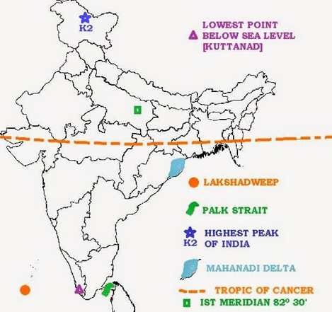
Answer: The Southernmost latitude of the Indian Union is Indira Point, located at the Southernmost tip of the Nicobar islands in the union territory of Andaman and Nicobar islands. It lies at a latitude of 6°45′ North.
7. Which Indian states border three countries?
Answer: The Indian states that border three countries are Sikkim, Arunachal Pradesh and Jammu and Kashmir.
8. Name the group of islands lying in the Arabian sea.
Answer: The Lakshadweep islands lie in the Arabian sea.
9. What is unique about the ‘Indira Point’?
Answer: Indira Point is the Southernmost point within the Indian Union, located in the Nicobar islands. It was submerged under sea water by the Tsunami of 2004.
10. Which countries are land neighbours of India, but are not considered as part of the Indian subcontinent?
Answer: The countries are Myanmar, Afghanistan and China.
11. Which union territory of India has the least area?
Answer: The union territory of Lakshadweep has an area of only 32 sq km, which is the least among all the union territories.
12. Which state of India has the least area?
Answer: The state of Goa has an area of 3702 sq km, which is the least among all the states (Delhi is considered as a union territory, not a state).
13. How many hours is the Indian Standard Time (1ST) is ahead or behind Greenwich Mean Time (GMT)?
Answer: Since, India is to the East of Greenwich (located at 0° longitude) and its standard time is calculated at 82°30′ E, India is 5.30 hours ahead of Greenwich Mean Time (GMT).
14. What is the latitude of the Southernmost point on the Indian main land?
Answer: The Southernmost point on the Indian main land is Kanyakumari at a latitude of 8°4′ N.
15. Which union territory was converted into a state in 1987?
Answer: Goa was a union territory when it became independent from Portuguese rule in 1961. It was made into a state in 1987.
16. Is it true that the land area of Russia is more than the combined areas of Australia and India?
Answer: Russia has a land area of 17.09 million sq km. Australia and India together have a combined land area of 7.69 + 3.28 million sq km = 10.97 million sq km. Thus, this is true.
17. India’s contacts with the world were established first by land routes or sea routes?
Answer: The land routes, because the various passes across the mountains in the North have provided passages to the ancient travellers, while the oceans restricted such interaction for a long time.
18. The Tropic of Cancer passes through which states of India?
Answer: The Tropic of Cancer passes through the states of Gujarat, Rajasthan, Madhya Pradesh, Chhattisgarh, Jharkhand, West Bengal, Tripura and Mizoram.
19. Which country has a common frontier with the four Indian states of Uttarakhand, Uttar Pradesh, Bihar, West Bengal and Sikkim?
Answer: The country having common frontier with these Indian states is Nepal.
20. If you intended to visit Kavarati during your summer vacations, which union territory of India will you be going to?
Answer: Kavarati is the capital of the union territory of Lakshadweep.
21. In which year did the Indira Point got submerged under the seawater?
Answer: 2004 is the year when Indira Point got submerged under the seawater.
22. Name the imaginary line in India along which time is taken as standard time.
Answer: Standard Meridian is the imaginary line in India along which time is taken as standard time.
23. What is the length of Indian coastline?
Answer: Length of Indian coastline is 7516.6 km.
24. What is the East-West extension of India in kilometres?
Answer: The distance of East-West extension of India in 2933 kms.
25. What is the position of India in respect of area in the world?
Answer: India holds 7th position in the world in term of area.
26. Name the water bodies that separate Sri Lanka from India?
Answer: Palk Strait and Gulf of Mannar are water bodies that separate Sri Lanka from India.
27. What is the length of Indian land boundary?
Answer: The length of Indian land boundary is 15200 km.
28. If you want to visit Lakshadweep during your winter holiday, which water body you have to cross?
Answer: We have to cross Arabian sea if we visit Lakshadweep.
29. How many countries in the world are larger than India in terms by land area? Name them according to their position?
Answer: There are six countries in the world larger than India. They are Russia, Canada, China, United States of America, Brazil and Australia.
30. They are Russia, Canada, China, United States of America, Brazil and Australia.
Answer: The distance of North-South extension of India in 3214 kms.
31 What is the North-South extension of India in kilometres?
Answer: The latitudinal line that divides India in two equal parts is Tropic of Cancer.
32. Which latitudinal line divides India into approximately two equal parts?
Answer: Indian Standard Time (1ST) is 5:30 hrs ahead of GMT (Greenwich Mean Time).
33. What is the time difference between 1ST and GMT?
Answer: The days and nights are almost equal at Kanyakumari because it lies near the equator
34. Why days and nights are almost of equal duration at Kanyakumari?
Answer: Bangladesh shares the longest boundary with India. It is 4053 km long.
35. Which country shares the longest boundary with India?
Answer: Gujarat has the longest coastline in India.
36. What is the total area of India’s land mass? What percentage of total geographical area of the world does it cover?
Answer: Total area of India is 3.28 million sq km. It covers about 2.4 per cent of the total geographical area of the world.
37. Which states of India neither have a coastline and nor have an International border?
Answer: The states of India which neither have a coastline and nor have an international border are Haryana, Madhya Pradesh, Chhattisgarh and Jharkhand.
38. What is the total land boundary of India?
Answer: The total land boundary of India is about 15200km.
39. What is the total length of India’s coastline?
Answer: The total length of India’s coastline (including the islands) is about 7517 km.
40. Which neighbour country lies to the South-East of the Nicobar Islands?
Answer: The neighbour country is Indonesia.
41. Which union territories (or part of them) are found on the West coast of India?
Answer: The union territories (or part of them) which are found on the West coast of India are Daman and Diu, and Mahe (part of Puducherry). Lakshadweep is off the West coast of India, not on it.
42. Find out the number of union territories along the Western and Eastern coasts.
Answer: Union Territories along the (a) Western Coast Lakshadweep, Daman and Diu, Dadra and Nagar Haveli and Mahe (belonging to Puducherry). (b) Eastern Coast Puducherry, Andaman and Nicobar islands.
43. Find out area wise which is the smallest and which is the largest state.
Answer: Area wise (a) Largest State Rajasthan (342239 sq km) (b) Smallest State Goa (3702 sq km)
44. Name the group of island lying in the Arabian sea.
Answer: Lakshadweep island lie in the Arabian sea.
45. Name the countries which are larger than India.
Answer: Russia, Canada, USA, China, Australia and Brazil are the – countries that are larger than India.
46. Which island group of India lies to its South-East?
Answer: Andaman and Nicobar islands lie to the South-East of India.
47. Which island countries are our Southern – neighbours?
Answer: Sri Lanka and Maldives are the two island countries that are the Southern neighbours of India.
48. In which hemisphere India is located?
Answer: India is located in northern hemisphere.
49. What is the latitudinal extent of India?
Answer: The main land extends between latitudes 804′ N and 3706′ N.
50. What is the longitudinal extent of India?
Answer: India lies between the longitudes of 6807′ E and 97025′ E.
51. Which tropic divides India into almost two equal parts?
Answer: The Tropics of Cancer (2303(r N).
52. Name the two Island groups of India.
Answer: Andaman and Nicobar Islands are located in Bay of Bengal and Lakshadweep Islands in Arabian Sea.
53. What is total area of Indian landmass?
Answer: Total landmass of India has an area of 3.28 million square Kms
54. Which countries are bigger than India in size?
Answer: Russsia, Canada, USA, China, Brazil and Australia.
55. What is the total length of coastline of the mainland including Andaman & Nicobar & Lakshadweep Islands?
Answer: The total length of the coastline of India is 7,516.6 Kms.
56. Which two seas are located around India?
Answer: The Arabian sea on the west and Bay of Bengal on the east of Peninsula.
57. What is the time lag between Gujarat and Arunachal Pradesh?
Answer: There is a time lag of 2 hours.
58. What is the standard meridian of India?
Answer: The standard Meridian of India is 82° 30’E.
59. From where does Standard Meridian pass in India?
Answer: The Standard Meridian of India passes through Mirzapur in Uttar Pradesh.
60. Why 82° 30′ E has been selected as the Standard Meridian of India?
Answer: 82° 30′ E has been selected as the Standard Meridian of India since it passes almost from the centre of India.
61. Do you justify Indian Ocean’s name after India?
Answer: Yes, as no other country has a longer coastline on the Indian Ocean as India has and indeed, it is India’s eminent position in the Indian Ocean which justifies the naming of an ocean after it.
62 What is the total length and width of India?
Answer: Total length of India is 3214 Kms and the width is 2933 Kms.
63. How had India kept her relationship with the world in ancient times?
Answer: Various passes across the mountains in the north have provided passages to the ancient travellers, while the oceans restricted such interaction for a long time.
64. Which ideas from India could reach the world?
Answer: The ideas of the Upanishads and Ramayana, the stories of Panchtantra, the Indian numerals and the decimal system could reach many parts of the world.
65. What commodities were taken from India to various parts of the world?
Answer: The spices, muslin and many other merchandise were taken from India to different countries.
66. How many states and union territories does India have?
Answer: India has 28 states and 7 union territories.
67. Which is the smallest and the largest state of India areawise?
Answer: The smallest state is Goa and the largest state is Rajasthan.
68. Name the states which do not have an international border or lie on the coast.
Answer: Madhya Pradesh, Chhattisgarh, Haryana, Jharkhand.
69. Name the states of India, sharing border with Pakistan.
Answer: Gujarat, Rajasthan, Punjab and Jammu and Kashmir.
70. Which states of India share border with China?
Answer: Jammu and Kashmir, Himachal Pradesh, Uttrakhand, Sikkim and Arunachal Pradesh.
71. Name the states sharing border with Myanmar.
Answer: Tripura, Mizoram, Manipur and Nagaland.
72. Which states of India share border with Bangladesh?
Answer: West Bengal, Bihar, Sikkim, Assam, Meghalaya and Tripura.
73. Which countries share their border with India?
Answer: India share its land boundaries with Pakistan and Afghanistan in the north west, China (Tibet), Nepal and Bhutan in the north, Myanmar and Bangladesh in the east.
74. Which two Island countries are India’s neighbours?
Answer: Sri Lanka and Maldives.
75. Which water bodies separates Sri Lanka from India?
Answer: Sri Lanka is separated from India by a narrow channel of sea formed by the Palk Strait and the Gulf of Mannar.
76. Name the Eastern coastal states of India.
Answer: Tamil Nadu, Andhra Pradesh, Orissa (Odisha) and West Bengal.
77. Name the Western coastal states from South to North?
Answer: Kerala, Karnataka, Goa, Maharashtra and Gujarat.
78. If you intend to visit Kavarati during summer vacation, which union territory you will be going to?
Answer: Lakshdweep Islands in Arabian Sea.
79 With which country do states of Uttarakhand, Uttar Pradesh, Bihar, West Bengal and Sikkim have common frontiers?
Answer: Nepal.
80. Name the states through which the Tropic of Cancer passes.
Answer: Gujarat, Madhya Pradesh, Chattisgarh, Jharkhand, W. Bengal, Tripura and Mizoram.
81. Name the place situated on three seas of India.
Answer: Kanyakumari.
82. Name the union territories of India.
Answer: Delhi, Daman and Diu, Dadar and Nagar Haveli, Puducherry (Pondicherry).
Short Answer Type Questions
1. Just before independence, how were the Provinces and states in India organised?
Answer: Just before independence in 1947, there were two types of states in India the Provinces and the Princely states. Provinces were ruled directly by British officials who were appointed by the Viceroy. Princely states were ruled by local, hereditary rulers, who acknowledged sovereignty of the British in return for local autonomy. Examples of the rulers of Princely states are the Nizam of Hyderabad and Maharaja Hari Singh of Jammu and Kashmir.
2. What is the strategic significance of India’s location in Asia?
Answer: The Indian land mass has a central location between East and the West Asia. The trans Indian Ocean routes which connect the countries of Europe in the West and the countries of East Asia provide a strategic central location to India.
The various passes across the mountains in the North have provided passages to the ancient travellers. These routes have contributed in the exchange of ideas and commodities since ancient times. Thus, India is very strategically located.
3. Give the reasons for selecting longitude 82°30′ as the Standard Meridian of India.
Answer: The latitudinal and longitudinal extent of the Indian main land is about 30°. Thus, from Gujarat to Arunachal Pradesh, there is a time difference of almost two hours. So the local time along the Standard Meridian of India (82°30′ E) passing through Mirzapur (in Uttar Pradesh) is taken as the Indian Standard Time for the whole country. This is near to the centre of the country and also an exact multiple of a half hour related to Greenwich in England, which is at 0° longitude.
4. Why is the difference between day and night durations not felt at Kanyakumari, but not so in Kashmir?
Answer: Since, the axis of rotation of the Earth is tilted at 23.5° to the perpendicular, the circle of illumination of the Earth varies from summer to winter. At the equator, it does not cause any time difference between day and night throughout the year, but North or South of it the durations vary. Kanyakumari is close to the equator, while Kashmir is far away. So, this difference is felt in Kashmir in winter or summer, but not at Kanyakumari.
5. Why 82030’E has been selected as the Standard Meridian of India?
Answer: From Gujarat to Arunachal Pradesh there is a time lag of two hours. Hence, time along the Standard Meridian of India (82° 30′ E) passing through Mirzapur (in Uttar Pradesh) is taken as the standard time for the whole country. Otherwise different regions of India would have different times, which would create problems; so, to have one common standard time for the whole country, this has been selected and called Indian Standard Time (1ST)
6. Classify the states into four groups each having common frontiers with (a) Pakistan (b) China (c) Myanmar (d) Bangladesh
Answer: States having common frontiers with (a) Pakistan Gujarat, Rajasthan, Punjab and Jammu and Kashmir (b) China Himachal Pradesh, Uttarakhand, Sikkim, Arunachal Pradesh and Jammu and Kashmir (c) Myanmar Manipur, Nagaland, Arunachal Pradesh and Mizoram (d) Bangladesh West Bengal, Asom, Meghalaya, Tripura and Mizoram
7. The Sun rises two hours earlier in Arunachal Pradesh as compared to Gujarat in the West, but the watches show the same time. How does this happen?
Answer: From Gujarat to Arunachal Pradesh there is a time lag of two hours, but the watches show the same time because the time along the Standard Meridian of India (82°30′ E) passing through Mirzapur in Uttar Pradesh is taken as the standard time for the whole country. Because the same standard time for the whole country has been adopted, the watches show the same time in Arunachal Pradesh and Gujarat and in all parts of the country.
8. Why the latitudinal extent influences the duration of the day and night as one moves from North to South?
Answer: The latitudinal extent influences the duration of day and night as one moves from South to North. When a place is near the equator, Sunrays falls on it straight, so days and nights are almost equal, but as it moves away from equator, sunrays falls on it slanting, so nights are longer and days are shorter. Places near equator have almost equal day and night.
9. Why is Indian Ocean named after our country? Give three reasons.
Answer: Indian Ocean is named after India because
(i) India has the longest coastline on the Indian Ocean.
(ii) India has a central location between East and West Asia.
(iii) India’s Southernmost extension Deccan Peninsula protrudes into Indian Ocean that makes it significant to international trade done through Indian Ocean.
10. Kota (in Rajasthan) is located at a latitude of about 76°E and Barpeta (in Asom) is at a latitude of about 91°E. What is the difference in local time at the two locations?
Answer: Since, Barpeta is East of Kota, the local time at Barpeta will be ahead of local time at Kota. A difference of 1° longitude is the same as 4 minutes time difference. Thus, the time difference between the two towns, = 4 min x (91°E-76°E) = 60 min.
11. When was the Suez Canal opened? How it has benefitted India?
Answer: The Suez Canal was opened in 1869. It has reduced the distance between India and Europe by 7000 km. Earlier the sea route from Europe to India was via cape of Good Hope which is the Southern tip of Africa. This route was very long. Thus, Suez Canal has reduced the distance between India and Europe.
12. Which longitude has been selected as the Standard Meridian of India? Explain any two reason for its selection.
Answer: 82° 30′ E longitude has been selected as the Standard Meridian of India. It has been selected because
(i) it passes through the middle of country.
(ii) like Standard Meridian of other countries it also divisible by 7 hrs and 30 minutes.
13. What is India’s latitudinal and longitudinal extent? What is the total area of India?
Answer: (i) Latitudinal extent: 8°4′ N to 37° 6′ N
(ii) Longitudinal extent: 68° T E to 97° 25′ E
(iii) The landmass of India has an area of 3.28 million sq km.
14. Explain why the cities of Mumbai and Chennai are able to see the noon Sun exactly overhead twice a year, but Delhi never sees it exactly overhead.
Answer: Mumbai and Chennai are South of the Tropic of Cancer (23.30′ N), while Delhi is North of it. Due to the tilt of the axis of rotation of the Earth by 23.5°, parts of the Earth North of the Tropic of Cancer will never have the noon Sun exactly overhead. Parts to its South will have the noonday Sun exactly overhead twice a year, between the time of the Vernal Equinox in March and the Autumnal Equinox in September.
15. Name the countries which are larger than India.
Answer: The countries which are larger than India are: (i) Russia
(ii) Canada
(iii) USA
(iv) China
(Iv) Brazil
(vi) Australia
16. What is the significance of India’s central location?
Answer: India is a south west extension of the Asian continent. The trans Indian Ocean routes which connect the countries of Europe in the west and the countries of East Asia provide a strategic central location to India. The Deccan Plateau protrudes into the Indian Ocean, thus helping India to establish close contact with West Asia, Africa and Europe from the western coast and East Asia and Southeast from the eastern coast.
17. The Sun rises two hours earlier in Arunachal Pradesh as compared to Gujarat in the west but the watches show the same time. How does this happen?
Answer: From Gujarat to Arunachal Pradesh there is a time lag of two hours. Hence, time along the Standard Meridian of India (82° 30′ E) passing through Mirzapur (Uttar Pradesh) is taken as the standard time for the whole country. So to have uniform time in the country, a Standard Meridian is taken and thus, the timings in Arunachal Pradesh and Gujarat are the same.
18. What do you know about the size of India?
Answer: The land mass of India has an area of 3.28 million sq. kms. India’s total area accounts for about 2.4 per cent of the total geographical area of the world. India is the seventh largest country of the world starting with Russia, Canada, USA, China, Brazil, Australia and India. India has a land boundary of about 15,200 km. The total length of the coastline of the mainland including Andaman and Nicobar and Lakshadweep is 7,576.6 kms.
Long Type Answer Questions
1. What is the longitudinal extent of India? What is its implication?
Answer: The longitudinal extent of India is from 68° 7’E to 97°25′ E. The Earth rotates from West to East. So, the Sun appears to move from East to West. There is a corresponding time difference of one hour for every 15° of longitudinal difference. Due to this there is local time variation of almost two hours between extreme Eastern and Western part of India. Due to this time variation one uniform Standard Meridian (82°30′) has been chosen for India, so that every place in India should have one standard time, that is known as Indian Standard Time (IST).
2. Why is India called a subcontinent? Name the countries which form a part of Indian subcontinent?
Answer: A subcontinent is a big geographical unit that have different geographical features than rest of the continent. The Indian subcontinent exhibits such features in the continent of Asia.
(i) It covers 2.4 per cent of the Earths total land area. It has long land frontier that is about 15200 km and nearly 7500 km long coastline.
(ii)Its natural frontiers like Himalayas in North and Deccan Peninsula provides it a unique identity on the globe.
(iii) Its longitudinal and latitudinal extent is 30°. The Himalayas separate it from rest of Asia. It enjoys unique climate, natural vegetation and culture. The Indian subcontinent comprises of India, Pakistan, Bangladesh, Nepal and Bhutan.
3. What influence did the land routes to India have on cultural exchanges in ancient times?
Answer: India’s contacts with the world have continued through the ages, but her relationships through the land routes are much older than her maritime contacts. The various passes across the mountains in the North have provided passages to the ancient travellers, while the oceans restricted such interaction for a long time. These routes have contributed in the exchange of ideas and commodities since ancient times. The ideas of the Upanishads and the Ramayana, the stories of panchtantra the Indian numerals and the decimal system. The spices, muslin and other merchandise were taken from India to different countries.
4. The central location of India at the head of the Indian Ocean is considered of great significance. Why?
Answer: The Indian land mass has a central location between the East and the West Asia. India is a Southward extension of the Asian continent. The trans Indian Ocean routes which connect the countries of Europe in the West and the countries of East Asia provide a strategic central location to India. The Deccan Peninsula protrudes into the Indian Ocean, thus helping India to establish close contact with West Asia, Africa and Europe from the Western coast and with South-East and East Asia from the Eastern coast. No other country has a long coastline on the Indian Ocean as India has indeed. Thus, India’s eminent position in the Indian Ocean which justifies the naming of an ocean after it.
5. Describe the location and size of India in three points each.
Answer:
Location
(i) India is the 7th largest country in the world which lies entirely in Northern hemisphere.
(ii) The main land extends between latitudes 8°4′ N and 37°6′ N and longitudes 68°7′ E and 97°25′ E.
(iii) The tropic of cancer (23°30′ N) divides the country into almost two equal parts.
Size
(i) The landmass of India has an area of 3.28 million sq km.
(ii) India’s total area accounts for about 2.4 per cent of the total geographical area of the world.
(iii)India has a land boundary of about 15200 km and the total length of coastline is 7516.6 km.
6. India has a long coastline which is advantageous. Explain.
Answer: No other country has a long coastline on the Indian Ocean as India has and indeed it has provided a significant boost to India’s maritime trade. Almost 90 per cent of India’s international trade is done through sea. The Deccan Peninsula protrudes into the Indian Ocean, thus helping India to establish close contact with West Asia, Africa and Europe from the Western coast and with South-East Asia and East Asia from the Eastern coast. India’s central location at the head of the Indian Ocean and its long coastline have much helped in its interaction through sea. The sea routes passing through the Indian Ocean provides easy connectivity to India with the West and the East. India has developed many ports on its Western and Eastern coast like Mumbai, Chennai, Kochi, Visakhapatnam, etc which have become major centres for international business.
7. How did India’s contact with rest of the world contribute in the exchange of ideas and commodities? Explain.
Answer: India has a long history of international ties. Despite living with in natural frontiers, Indian society has not developed in isolation. It has influenced the rest of the world and in return has also been influenced by the rest of the world. India’s contact with the outside world was much before the sea routes. The various passes across the Himalayas has provided gateway to many ancient travellers. While Ocean restricted such interaction. These routes have contributed in exchange of ideas and commodities since ancient times.
Due to unique position in Asia, the ancient land routes, including famous ‘Silk Route’ passed through the Indian subcontinent. The ideas of the Upanishads, the Ramayana, the Gita and other Indian scriptures were known to the world in older ages. The Indian numerals as well as decimal system long back crossed the border. The Arabs took these ideas to the West. India’s silk, spices, handicrafts, muslin and other merchandise were taken from India to different countries. The Greek enriched the Indian culture with their contribution in the field of architecture, science, etc. Islamic influence (from West Asia) is clearly visible in architectural styles of domes, arch, minarets, etc.
8. India said to enjoy a strategic position with reference to the International Trade Route. In your view which features provide India a strategic advantage?
Answer: India occupies a unique position on the globe. It enjoys a unique proximity with Europe, Africa and Australia. The Indian landmass has a central location between East and West Asia. India is Southward extension of Asia thus it forms the South-Central Peninsula of world largest continent. The Deccan Peninsula, India’s Southward extension protrudes into Indian Ocean and divides it into two seas, the Arabian sea on the West and the Bay of Bengal on its East.
The Deccan Peninsula helps India to establish easy contact with West Asia, East Africa and Europe from Western coast also establishes contacts with South-East Asia, East Asia and Australia from Eastern coast. India has the longest coastline in Indian Ocean. These geographical features provides India a significant edge in International trade. Lakshadweep, Puducherry and Delhi.
9. Why is the difference between the durations of day and night hardly felt at Kanyakumari but not so in Kashmir?
Answer: (i) The circle of illumination divides the equator into two equal parts. The days and nights are, therefore, of the same duration at the equator.
(ii) As Kanyakumari is quite near the equator, the day and night difference is hardly one hour.
(iii) But as we move away from the equator towards the poles, the variation (difference) in the duration of day and night becomes greater. It is because of the unequal division of the parallels of latitudes by the circle of illumination.
(iv) Kashmir is over 300 away from the equator and so the difference in duration of day and night is over 4 hours there.
10. What is the significance of India’s central location?
Answer: (i) India is very favourably located in relation to Eurasia, Africa and Australia.
(ii) It occupies central position in the eastern hemisphere.
(iii) It lies at the head of the Indian Ocean. It is the largest country with the largest coastline on the Indian ocean. The third largest Ocean is rightly named after India as the Indian Ocean.
(iv) India’s location has many economic advantages. It helped in establishing economic and cultural contacts with the East and the West in ancient times.
(v) It is favourably located on the world’s highway of trade and commerce, both to the east and the west. There are some prominent air routes and sea routes passing through the Indian subcontinent.
11. Why is 82° 30′ E selected as the Standard Meridian of India?
Answer: The 82° 30′ E Meridian has been selected as the Standard Meridian of India for the following reasons:
(i) There is a general understanding among the countries of the world to select a Standard Meridian in the multiples of 71/20 east and west of Prime Meridian. It is equal to half an hour.
(ii) A country’s standard time is derived from such a Central Meridian. The minimum difference of time between two consecutive Standard Meridians should be half an hour.
(iii) Another consideration is that the central meridian of a country should pass through, as far as possible, from its centre.
12. Why is the difference between the durations of day and night hardly felt at Kanyakumari but not so in Kashmir?
Answer: These places do not have the same duration of day and night. The circle of illumination divides the Equator into two equal parts. The days and nights are, therefore, of the same duration at the equator. As Kanyakumari is quite near the equator the day-night difference is hardly one hour there. But as we move away from the equator towards the poles, the variations in the duration of day and night becomes greater. It is because of the unequal division of the parallels of latitude by the circle of illumination. Kashmir is over 30° away from the equator and so the difference in duration of day and night is over four hours there.
13. What are India’s unique locational features?
Answer: (i) India lies completely on the north of the equator. So it is situated in the Northern Hemisphere.
(ii) The Tropic of Cancer passes through the middle of India. While its southern part (i.e., the peninsular India) falls in the tropical zone, the northern half lies in the subtropical zone or warm temperate zone.
(iii) India is also situated to the east of the Prime Meridian. It lies not only in the Eastern Hemisphere but also has central position in it.
(iv) India occupies the South-Central peninsula of the world’s largest and the most popular continent, Asia.
(v) It also lies at the head of the Indian Ocean. It has the longest coastline on this ocean.
14. What is the location of India in the world?
Answer: India is very favourably located in relation to Eurasia, Africa and Australia. It occupies central position in the Eastern hemisphere or the Orient. It forms South-Central peninsula of Asia. It lies at the head of the Indian Ocean. It is the largest country with the longest coastline on the Indian Ocean. The third largest ocean is rightly named after India-as the Indian Ocean. India’s location has many economic advantages. It helped in establishing economic and cultural contacts with the East and the West in ancient times. It is favourably located on the world’s highways of trade and commerce, both to the east and the west.
15. Classify the states into five groups each having common frontiers with Pakistan, China, Myanmar, Bangladesh and Nepal.
Answer: (i) Pakistan: Jammu and Kashmir, Punjab, Rajasthan and Gujarat.
(ii) China: Jammu and Kashmir, Himachal Pradesh, Sikkim and Arunachal Pradesh.
(iii) Myanmar: Arunachal Pradesh, Nagaland, Manipur, Mizoram.
(iv) Bangladesh: Bihar, West Bengal, Jharkhand, Assam, Meghalaya and Tripura.
(v) Nepal: Uttarakhand, U.R, Bihar, West Bengal and Sikkim.
16. How has India developed relationships with the world through the land route?
Answer: The passes across the mountains in the north have provided passages to the ancient travellers. These routes have contributed in the exchange of ideas and commodities since ancient times. The ideas of Upanishads, Ramayana, the stories of Panchtantra, the Indian numerals and the decimal system could thus, reach many parts of the world. The spices, muslin and other merchandise were taken from India to different countries. On the other hand, influence of Greek sculpture, their architectural styles of domes arid minarets can be seen in India.
17. Throw more light on India occupying an important and strategic position in South Asia.
Answer: (i) India has 28 States and 7 Union Territories.
(ii) India shares its land boundaries with Pakistan and Afghanistan in the north-west, China (Tibet), Nepal and Bhutan in the north and Myanmar and Bangladesh in the east.
(iii) Our southern neighbours across the sea consist of the two island countries, namely Sri Lanka and Maldives.
(iv) Sri Lanka is separated from India by a narrow channel of sea formed by the Palk Strait and the Gulf of Mannar while Maldives Islands are situated to the South of the Lakshadweep Islands. India has had strong geographical and historical links with her neighbours.
18. Why 82°30′ E has been as the standard meridian of India?
Answer: 82°30’E meridian has been selected as the standard meridian of India for the following reasons:
(i) This is a general understanding among the countries of the world to select a Standard Meridian in multiples of 7°30′ east and west of Prime Meridian. It is equal to half an hour.
(ii) A country’s standard time is derived from such a central meridian. The minimum difference of time between two consecutive standard meridians should be half an hour.
(iii) From Gujarat to Arunachal Pradesh there is a time lag of two hours. Hence, time along the standard meridian of India (82°30’E) passing through Mirzapur (U.P.) is taken as the standard time for the whole country.