Extra Questions for Class 9 Geography Chapter 2 Physical Features of India
Class 9 Social Science Geography Chapter 2 Physical Features of India extra questions and answers available here in PDF format. Solving class 9 extra questions help students to revise the Chapter most competently. We prepared these questions with PDF as per the latest NCERT book and CBSE syllabus. Practising these questions before the exam will ensure excellent marks in the exam.
Class 9 Geography Chapter 2 extra Questions and Answers
Very Short Answer Questions
1. What is the location of the Purvachal mountain range in India?
Answer: Purvachal range lies along the Eastern edge of India and forms the boundary with Myanmar.
2. ‘Folding’ and ‘faulting’ are the result of what geological actions?
Answer: ‘Folding’ and ‘faulting’ are the result of movement of tectonic plates.
3. Why is the Himadri mountain range called by this name?
Answer: Himadri in Sanskrit means ‘mountain top of snow’ and this range is perpetually snow bound.
4. What is orographic rainfall?
Answer: This is rainfall caused when masses of air pushed by wind are forced up the side of elevated land formations like mountains. Orography is the study of the physical geography of mountains and mountain ranges.
5. Which island in the Lakshadweep group of islands has a bird sanctuary?
Answer: The bird sanctuary is located on Pitti Island.
6. Which variety of rock is used for making talcum powder?
Answer: Soap stone rock is used for manufacture of talcum powder, as it is a very soft rock.
7. What do we mean by the term Bhangar?
Answer: Bhangar is the older alluvial soil region lying above the flood plains and presenting a terrace like feature.
8. Which two well-known rivers originate near the Mahadeo hills?
Answer: The rivers originating near the Mahadeo hills are the Narmada and the Son.
9. The terai belt lies North of which belt?
Answer: The terai belt lies North of the Bhangar belt.
10. What is the name of the part of the Himalayas lying between the Kali and the Tista rivers?
Answer: The part of the Himalayas lying between the Kali and the Tisca rivers is called Nepal Himalayas.
11. What is the location of the Satpura mountain range in comparison with the Aravali mountain range?
Answer: The Satpura range is to the South of the Aravali range.
12. Which plates originally formed a part of Gondwana land?
Answer: The plates originally forming Gondwana land were the African plate, Indo-Australian plate and the South American plate.
13. What is the variation in height in the Shiwaliks mountain range?
Answer: The height of the Shiwaliks mountain range varies from 900 to 1100m.
14. Which area of India is a flat land of extensive alluvial deposits?
Answer: The Northern plains is a flat land having extensive alluvial deposits from the rivers flowing in it.
15. Which major rivers of the Indian subcontinent flow into the Arabian sea?
Answer: The major rivers of the Indian subcontinent flowing into the Arabian sea are Indus (with a delta) and the Narmada and Tapi (as estuaries).
16 Why do landslides occur frequently in the Shiwaliks?
Answer: The Shiwaliks are composed of unconsolidated sediments brought down by rivers from the main Himalayan ranges and thus are prone to landslides.
17. Arrange the given mountain peaks in order of height, starting from the lowest: Doda Betta, Kanchenjunga, Mahendragiri and Namcha Barwa.
Answer: The heights of the peaks are 1. Mahendragiri 1501 m (lowest) 2. Doda Betta 2637 m3. Namcha Barwa 7756 m 4. Kanchenjunga 8598 m (highest)
18. What makes up the habitat in which coral polyps flourish?
Answer: The coral polyps flourish in a habitat consisting of shallow warm water which does not have mud. This kind of habitat is found in Lakshadweep.
19. The state of Meghalaya forms a part of which physiographic division of India?
Answer: Meghalaya is part of the Eastern extension of the Peninsular plateau.
20. Arrange the given ranges of the Himalayas starting from the Westernmost and moving Eastwards Assam Himalayas, Kumaon Himalayas, Nepal Himalayas and Punjab Himalayas.
Answer: The order is Punjab Himalayas (Westernmost), Kumaon Himalayas, Nepal Himalayas and Assam Himalayas (Easternmost).
21. Are the Aravali hills located in the Western Ghats or the Eastern Ghats?
Answer: The Aravali hills are neither in the Eastern nor in the Western Ghats, but are located North of both on the Peninsular plateau.
22. Which of the two is having a higher average height, the Eastern Ghats or the Western Ghats?
Answer: The average height of the Western Ghats is 900 to 1600 m, whereas the average height of the Eastern Ghats is only about 600 m. Thus the Western Ghats are higher.
23. What is the Southern part of the Western coastal plains known as?
Answer: This is known as Malabar (mostly in Kerala).
24. In which mountain range is the Khyber pass located?
Answer: The Khyber pass is located in the Sulaiman Range (Afghanistan-Pakistan border).
25. What is the highest peak in the Eastern Ghats and what is its height?
Answer: Mahendragiri at a height of 1501 m is the highest peak in the Eastern Ghats.
26. What do you understand by term “Peninsula”?
Answer: Peninsula is a landmass that is bounded by sea on three sides.
27. What is the name of Western coastal strip that lies in South of Goa?
Answer: Konkan Region.
28. Name the oldest part of Indian landmass.
Answer: The Peninsular plateau is the oldest landmass of India.
29. Name the hills that lies at the junction of Western and Eastern Ghats.
Answer: The Nilgiri hills in Tamil Nadu lies at the junction of Eastern and Western Ghats.
30. What is the name of the wet and swampy belt of Northern region?
Answer: The wet, swampy and marshy belt of Northern plains are known as terai.
31. What is the name of the part of Northern plain formed by older alluvium?
Answer: The part of Northern plains formed of older alluvium is called the Bhangar.
32. Name the Indian state where Kanchenjunga is located?
Answer: Kanchenjunga is located in the Indian state of Sikkim.
33. Which part of the Indian coastal plain is known as Northern Circ00ar?
Answer: The Northern part of Eastern coastal plains is known as Northern Circar.
34. Name the highest peak which lies in Western Ghats.
Answer: Anai Mudi is the highest peak in Western Ghats. It’s height is 2695 metres.
35.Which island of India has the only active volcano in India?
Answer: India’s only active volcano is found on Barren island in the Andaman and Nicobar group of islands.
36. What types of actions can happen when two tectonic plates collide with each other?
Answer: When two tectonic plates collide with each other, this can lead to folding, faulting and volcanic activity.
37. Which continents of today were part of the Gondwana land?
Answer: The Gondwana land included India, South Africa and South America as one single land mass.
38. Which plateaus lies between the Aravali and the Vindhyan ranges?
Answer: Malwa plateau lies between the Aravali and the Vindhyan ranges.
39. Name of the island group of India having coral Vindhyan.
Answer: Lakshadweep islands are composed of small coral islands.
40. Name the three prominent sub-ranges of the Himachal Himalayas.
Answer:The sub-ranges are named Pir Panjal, Dhaula Dhar and Mahabharat.
41. Which are the three types of plate boundaries? Which one of them lies in the Himalayan belt?
Answer: The three types of plate boundaries are Convergent, Divergent and Trans form. The Himalayas have been formed by the convergent boundary.
42. Find out the name of the states where the highest peaks are located.
Answer: States where highest peaks are located are
(a) Jammu and Kashmir (Nanga Parbat)
(b) Sikkim (Kanchenjunga)
(c) Uttarakhand (Nanda Devi, Kamet)
43. Find out the location of Mussoorie, Nainital, Ranikhet from your atlas and also name the state where they are located.
Answer: All the three towns are in the state of Uttarakhand in the range called lesser Himalaya or Himachal.
44. What are tectonic plates?
Answer: The convectional currents below the Earth’s crust split the crust into a number of pieces. These pieces are called tectonic plates e.g., Eurasia plate, Indo-Australian plate, etc.
45. What is the Bhabar?
Answer: Bhabar is a narrow belt of land about 8 to 16 km wide and covered with pebbles deposited by the rivers and lying parallel to the slopes of the Shiwaliks.
Short Answer Type Questions
1 Name five hill stations in the Himalayas.
Answer: These can be any of the following Pahalgam, Srinagar, Gulmarg (in Jammu and Kashmir), Shimla, Kullu, Manali (in Himachal Pradesh), Mussoorie, Nainital, Ranikhet (in Uttarakhand) and Darjeeling (in West Bengal), besides many others.
2. What do you understand by tectonic plates?
Answer: Tectonic plates are sub-layers of the Earth’s crust (lithosphere) that move, float and sometimes fracture and whose interaction causes continental drift, earthquakes, volcanoes, mountains and oceanic trenches. The Earth’s crust has been formed out of seven major and some minor plates.
3. What geological process formed the present landforms of India?
Answer: The movements of tectonic plates during different geological periods has formed the present landforms of India. Besides this process, other processes like weathering, erosion and deposition have been continuously modifying the relief.
4. Make a comparison between the Shiwaliks and Himachal Himalayas based on the following
(i) Composition
(ii) Age
(iii) Altitude
Answer:
| Mountain Range | Shiwaliks | Himachal Himalayas |
| Composition | Thick gravel and alluvium | Highly compressed and altered rocks |
| Age | 5 to 16 million years | 25 million years |
| Altitude | Between 900 and 1100 m | 3700 to 4500 m |
5. Give a description of the Shiwaliks.
Answer: The Shiwaliks are the outermost range of the Himalayas. Their altitude varies from 900 to 1100 m and the length of the range is about 2400 kms from Jammu and Kashmir to Arunachal Pradesh. The width of this range varies from 10 to 50 kms. It is composed of thick gravel and alluvium brought down by rivers.
6. Compare the features of the Western Ghats with those of the Eastern Ghats in tabular form.
Answer:
| Feature | Western Ghats | Eastern Ghats |
| Average height | 900 to 1600 m | Average 600 m |
| Locations | Western edge of Deccan plateau | Eastern edge of Deccan plateau |
| Formation | Continuous | Discontinuous and irregular |
| Rainfall | Cause orographic rain | Receive less rain than Western Ghats |
| Rivers originating | Source of the three longest Peninsular rivers | Only small length rivers originate here |
7. How were the Northern plains formed?
Answer: The Northern plains have been formed by three major river systems, namely the Indus, the Ganga and the Brahmaputra, along with their tributaries. These plains are formed of alluvial soil. The deposition of alluvium in a vast basin lying at the foot hills of the Himalayas over millions of years formed these fertile plains. With a rich soil cover combined with adequate water supply and favourable climate, it is agriculturally a very productive part of India.
8. Assume that you have recently travelled in the Indian desert. Describe the desert to a person not living in India.
Answer: The desert in India lies to the West of the Aravali hills in the states of Rajasthan and Gujarat. In India, it covers an area of more than 250000 square km. It has an arid climate with annual rainfall of less than 150 mm. It is a sandy plain with very little vegetation. Barchans (crescent shaped dunes) cover larger areas, but longitudinal dunes become more prominent near the Indo-Pakistan boundary.
9. What are the differences between the Central Highland and Deccan Plateau?
Answer:
| Feature | Central Highlands | Deccan Plateau |
| Composition | Some part is composed of granite and gneisses. while some part is covered with black soil | Composed of igneous rocks like basalt and granite |
| Location | North of the Narmada river | South of the Narmada river |
| Constituent parts and Extensions | Malwa Plateau, Bundelkhand, Baghelkhand and Chhotanagpur Plateau | Mahadev. Kaimurand Maikal hills. Its Eastern extensions are Garo, Khasi, Jaintia, North Cachar and Karbi- Anglong hills |
| Rivers | Chambal, Sind, Betwa and Ken | Mahanadi, Godavari, Krishna and Kaveri |
10. Find out the names of the glaciers and passes that lie in the Great Himalayas.
Answer: The names of the glaciers that lie in the Great Himalayas are
(a) Siachen Glacier -Jammu and Kashmir
(b) Godwin Glacier -Jammu and Kashmir
(c) Gangotri Glacier -Uttarakhand
(d) Yamunotri Glacier -Uttarakhand Passes that lie in the Great Himalayas Himachal Pradesh Rohtang Pass, Karakoram Pass, Rupin Pass Sikkim Nathu La, Jelep La Uttarakhand Mana Pass
11. Name the three major divisions of the Himalayas from North to South.
Answer: The three major divisions of the Himalayas from North to South are as follow
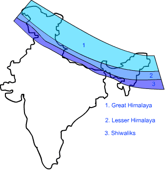
(a) The Great or Inner Himalayas or the Himadri It is a continuous range consisting of the highest peaks.
(b) Himachal or Lesser Himalayas The range lying to the South of the Himadri is known as Himachal or Lesser Himalayas.
(c) Shiwaliks The outermost range of the Himalayas is known as the Shiwaliks. These are the foot hill ranges and represent the Southernmost division of the Himalayas.
12. In Lakshadweep, there is a bird sanctuary on Pitti island. This island is uninhabited. Should some people be allowed to live on Pitti island? If they are allowed, what can be the harmful effects?
Answer: Humans should not be allowed to inhabit Pitti island, as this will affect the breeding of the birds on it, as the presence of humans along with their activities will disturb them and the birds may move elsewhere. The harmful effects of human activity are
(i) Pollution of fresh water sources on the island due to human activity. The birds will not get clean water to drink.
(ii) Hunting of birds for food by the humans will not allow the birds to stay on the island.
13. In India, the Northern mountains are the major sources of water and forest wealth. What negative effects can result from uncontrolled exploitation of water and forest resources of the mountains?
Answer: Biodiversity will be affected on a large scale if there is uncontrolled exploitation of water and forest resources. Animals will lose their natural habitat and climatic changes will occur after a few years. So, use of natural resources of the mountains should be done with care so that the ecology is not seriously disturbed. Only a very limited amount of water and forest reserves should be used. Trees can be freshly planted to replace the forests being exploited.
14. Describe any three features of Shiwaliks range. Or Name the outermost range of Himalayas. Write any two characteristics of it.
Answer: The outermost range of Himalayas are known as shiwaliks. Following are the main features of Shiwaliks range
(i) The height of Shiwaliks range varies between 900 and 1100 metres.
(ii) They are composed of unconsolidated sediments brought down by rivers from the main Himalayan ranges.
(iii) These valleys are covered with thick gravel and alluvium.
15. State any three difference between the Himadri range and Shiwalik range? Or Describe any three features of Himadri.
Answer: The differences between Himadri and Shiwalik ranges are
| Himadri Range | Shiwalik Range |
| 1. This is the Northernmost and innermost range of Himalayas. | 1. This is the outermost range of Himalayas. |
| 2. The average altitude of this range is 6000 metres. | 2. The average altitude varies from 900 to 1100 metres. |
| 3. The core of this part of Himalayas is composed of granite. | 3. These ranges are composed of unconsolidated sediments brought down by rivers from the main Himalayan ranges. |
16. What do you understand by Duns? Where are they situated in our country?
Answer: The longitudinal valley lying between lesser Himalayas and Shiwaliks are known as Duns. Dehra Dun, Kotii Dun and Patii Dun are some of the well-known Duns. They are covered with thick deposits of gravel and alluvium.
17. Write any three differences between Bhangar and Khadar.
Answer:
| Bhangar | Khadar |
| 1. It is composed of older alluvium. | 1. The newer and younger deposits of flood plains are called Khadar. |
| 2. It is the largest part of Northern plain composed of older alluvium. | 2. The younger alluvium covers low-lying region and gets renewed almost every year by local flood. |
| 3. It lies above the flood plains of rivers and present a terrace like feature. | 3. They provides the best fertile soils, level land and good climatic conditions. |
18. Name the coastal strip of Peninsular plateau lying along Arabian sea. Describe any four features of it.
Answer: The coastal strip along the Arabian sea is Western oastal strip.
Features of Western coastal strip are:
(i) It lies between the Western Ghats and Arabian sea.
(ii)It is a narrow plain. It has three sections.
(iii) The Northern part of the coast is knownas Konkan.
(iv) The central stretch of this coastal strip is known as Kannad Plain while Southern stretch is known as the Malabar coast.
19. Name the group of Indian islands that is of coral origin. Mention its capital and the island in the group that has a bird sanctuary. Or Which group of island is located in Arabian sea? Write any four features of these islands. What is orographic rainfall? Which part of the Peninsular plateau causes orographic rainfall?
Answer: (i) The Lakshadweep group of islands in the Arabian sea is of coral origin. It is composed of coral deposits on the sea bed.
(ii) Kavaratti Island is the capital of the Lakshadweep.
(iii) The Pitti Island, which is uninhabited, has a bird sanctuary.
(iv) They are in proximity with Malabar coast in Kerala.
(v) It has great diversity of flora and fauna.
20. What do you mean by the ‘Theory of Plate Tectonics’?
Answer: Earth scientists have explained the formation of physical features with the help of some theories and one such theory is the ‘Theory of Plate Tectonics’. According to this theory, the crust i.e.- the upper part of the Earth has been formed out of seven major and some minor plates. The movement of these plates resulted in building up of stresses within the plates, leading to folding, faulting and volcanic activities.
21. What are the three types of plate movements on the Earth?
Answer: (i) Coverage boundary: When some plates come towards each other, they form a convergent boundary. It may also be called folding movements.
(ii) Divergent boundary: When some plates move away from each other they form a divergent boundary. It is also called faulting movements.
(iii) Transform boundary: In the event of two plates coming together, they may either collide and crumble or may slide under the other and form the transform boundary.
22. How were the northern plains formed?
Answer: The Himalayan uplift out of the Tethy’s sea and subsidence of the northern flank of the Peninsular plateau resulted in the formation of a large basin. In due course of time, this depression gradually got filled with the deposition of the sediments by the rivers flowing from mountains in the north. A flat land with extensive alluvial deposits by these rivers led to the formation of the Northern Plains of India.
23. Name the major physiographic divisions of India.
Answer: The major physiographic divisions of India are:
(i) The Himalayan Mountains
(ii) The Northern Plains
(iii) The Peninsular Plateau
(iv) The Indian Desert
(v) The Coastal Plains
(vi) The Islands
24. Give a brief description of the Himalayan mountains.
Answer: The Himalayas, geologically young and structurally fold mountains stretch over the northern borders of India. These mountain ranges run in a west- east direction from the Indus to the Brahmaputra. The Himalayas are loftiest and one of the most rugged mountain barriers of the world. They form an arc, which covers a distance of 2,400 kilometres.
25. Why are the Shiwalik ranges prone to earthquakes?
Answer: The Shiwalik ranges are still in the process of folding. This is the youngest range of the Himalayas formed by unconsolidated rock material. Therefore, these ranges are prone to earthquakes and landslides.
26. Classify the Himalayas on the basis of regions from the West to East.
Answer: This division of the Himalayas is demarcated by the river valleys.
(i) Punjab Himalayas: This part of the Himalayas lies between the rivers Indus and Satluj. It is also known as Kashmir and the Himachal Himalayas.
(ii) Kumaon Himalayas: This part of the Himalayas lies between Satluj and Kali rivers.
(iii) Nepal Himalayas: This part of the Himalayas lies between Kali and Teesta rivers.
27. What do you know about ‘Purvanchal?
Answer: The Eastern Hills are collectively known as Purvanchal. These hills running through the north-eastern states are mostly composed of strong sandstones which are sedimentary rocks. They are covered with dense forest; they mostly run as parallel ranges and valleys. Purvanchal comprises of the Mizo hills, Naga hills, Manipur hills, Patkai Bum, Garo, Khasi and Jaintia hills.
28. Why are the Northern Plains the agriculturally productive parts of India?
Answer: The Northern Plains are drained by three river systems: the Indus, Ganga and the Brahmaputra along with their tributaries. They deposit alluvial soils in vast basins lying at the foothills of the Himalayas. With a rich soil cover combined with adequate water supply and favourable climate, it is agriculturally a very productive part of India.
29. How are riverine islands formed?
Answer: The rivers coming from the northern mountains carry alluvium with them and do the depositional work. In the lower course, due to gentle slope, the velocity of the river decreases which results in the formation of riverine islands.
30. Where are the famous Passes of Himalayas located?
Answer: Shipkila Pass: It is located on the Tibet-Himalaya Road. It lies in the Satluj valley in Himachal Pradesh. Nathula Pass: It is on the way from India to Lhasa. It lies in the Chumbi valley in Sikkim. Bomdila Pass: It lies further east in Arunachal Pradesh. It leads to Arunachal- China border.
31 What do you know about valleys and duns in Himalayas?
Answer: The Kashmir valley is so beautiful that it is described as ‘paradise on the earth’. The Kangra and Kullu valleys in Himachal Pradesh are also beautiful. The Kathmandu valley in Nepal is famous as well. Small valleys in Kumaon Himalayas of Uttarakhand are called ‘duns’. Some of the famous duns are Dehra Dun, Kotii Dun and Patii Dun.
32 Describe the ‘Peninsular Plateau’ of India.
Answer: The Peninsular plateau is a tableland and is composed of the old crystalline, igneous and metamorphic rocks. It was formed due to the breaking and drifting of the Gondwana land. It has broad and shallow valleys and rounded hills. It consists of two broad divisions?Central highlands and Deccan Plateau. The eastward extensions of this plateau are locally known as the Bundelkhand and Baghelkhand.
33. How Northern Plains of India are formed?
Answer: (i) The northern plains have been formed by the interplay of the three major river systems the Indus, the Ganga and the Brahmaputra along with their tributaries.
(ii) The deposition ofallumium in a vast basin lying at the foothills of the Himalayas over millions of years, formed this fertile plain.
(iii) With a rich soil cover, combined with adequate water supply and favourable climate, it is agriculturally a very productive part of India.
34. Why is the black soil area in the peninsular part called Deccan Trap?
Answer: (i) This black soil area of peninsular plateau is of volcanic origin, hence the rocks are igneous.
(ii) Actually these rocks have denuded over time and are responsible for the formation of black soil.
(iii) Due to continuous flow of lava, an extensive lava plateau has been formed, which is called Deccan Trap.
35. How were Andaman and Nicobar Islands formed?
Answer: (i) It is believed that these islands are an elevated portion of submarine mountains in the Bay of Bengal.
(ii) They are located on a submerged or submarine hill range and are probably formed by the volcanic eruptions.
(iii) Some of the volcanic mountains are still active over here. They are larger in size and are known for their variety of flora and fauna.
36. Which are the coral islands of India?
Answer: (i) Lakshadweep are the coral islands of India as they are formed by coral deposits.
(ii) Such islands are formed by the deposition of skeletons of microscopic species, called coral polyps on the seabed.
(iii) They live only in shallow warm waters. Many of these islands are in ring shape or horse shoe shape, called atolls.
These islands are located in the warm water of Arabian Sea.
Long Answer Type Questions
1. What are Tectonic plates? Distinguish between converging and diverging tectonic plates?
Answer: Tectonic Plates According to the “Theory of Plate Tectonics”, the Earth’s crust (upper part) has been formed out of seven major and some minor plates. They comprise the Earth’s solid upper crust as well as parts of the denser mantle below.
The movement of the plates results in the building up of stresses within the plates and continental rocks above, leading to folding, faulting and volcanic activity. When some plates move or come towards each other, they are called converging plates. In this case they may collide, crumble or slide under each other. When some plates move away from each other, they are called diverging plates. In this case they form new crust or the sea floor spreads.
2. Compare the actions of converging and diverging tectonic plates.
Answer: When two tectonic plates converge, the crust is destroyed and recycled back into the interior of the Earth as one plate dives under another. Mountains and volcanoes are often found where plates converge. The Himalayas were formed due to the converging of the Eurasian plate with the Indo-Australian plate. At divergent boundaries, new crust is created as two plates pull away from each other. Oceans are born and grow wider where plates diverge or pull apart. When a diverging boundary occurs on land, a ‘rift’ will arise and the mass of land will break apart into distinct land masses. A divergent boundary between the North American and Eurasian plates has caused a ridge in the middle of the Atlantic Ocean.
3. ‘The Indian landmass shows a great physical contrast.’ Explain this statement.
Answer: India’s landmass has great contrasts as the Peninsular plateau in the South is a very old landmass (65 million years), whereas the Himalayas in the North are fairly new (about 25 million years) .Tectonically, the Himalayas and the Northern plains are unstable zones, whereas the Peninsular plateau is very stable. Over millions of years, weathering forces have made the contrast sharper. While the Himalayas are composed of sedimentary and metamorphic rocks and the Northern plains are made of deposited alluvium, the Peninsular plateau is made up of igneous and metamorphic rocks. Whereas the Himalayas have lofty peaks and steep sided valleys, the Deccan region has gently rising ranges and wide valleys. Thus, the Indian landmass shows a great physical contrast.
4. Describe the river systems of the Northern plains, giving their main features.
Answer: The three river systems in the Northern plains from East to West are the Brahmaputra, Ganga and Indus systems. A large part of the Indus system lies in Pakistan. The Indus and its tributaries – Jhelum, Chenab, Ravi, Beas and Satluj originate in the Himalayas. This section of the plain is dominated by the doabs. The Ganga plain extends between the Ghaggar and Tista rivers. It spreads over the states of Haryana, Delhi, Uttar Pradesh, Bihar, part of Jharkhand and West Bengal. It has tributaries like the Yamuna, Gomati, Ghaghara, Son, Gandak and Kosi. The Brahmaputra Plain lies in Arunachal Pradesh and Asom, where it is joined by its tributaries like the Dibang, Lohit, Raidak and Sankosh.
5. Describe the coastal plains, giving their main features. Or Describe any five features of coastal plains of India.
Answer: The coastal plains are narrow coastal strips running along the Arabian sea in the West and the Bay of Bengal in the East. They are separated from the Deccan plateau by the Western and Eastern Ghats respectively. The plain in the West has three parts, Konkan in the North, Kannad in the centre and Malabar in the South. On the eastern side, we have the Northern circars in the north and the coromandel coast in the south. The Western plain is narrower in width (about 50 km) compared to the Eastern plain (100 to 130 km). The Mahanadi, Godavari, Krishna and Kaveri rivers form deltas on the East coast, while the Narmada and Tapi form estuaries on the West coast.
6. Describe the islands of India. Or Give a brief description of two islands of India
Answer: India has the Union Territories of Lakshadweep in the Arabian sea and the Andaman and Nicobar islands in the Bay of Bengal. Lakshadweep is a group of coral islands near the Malabar coast of Kerala. The Pitti island here has a bird sanctuary. The total land area of this group is only about 32 square km. The Andaman and Nicobar islands are an elongated chain with dense forests and an equatorial climate. This chain has the only active volcano in India on Barren island. The Southernmost point of the Indian Union, Indira Point, at the end of the Nicobar chain, was sunk due to the Tsunami of December, 2004. The total land area of this chain is 8249 square km.
7. Distinguish between
(i) Converging and diverging tectonic plates.
(ii) Bhangar and Khadar.
(iii) Western Ghats and Eastern Ghats.
Answer: (i) Difference between converging plates and diverging plates
| Converging Tectonic Plates | Diverging Tectonic Plates |
| The plates that come towards each other and form a convergent boundary. | The plates that move away from each other and form divergent boundary |
(ii) Differences between Bhangar and Khadar
| Bhangar | Khadar |
| (a)Bhangar is old alluvial soil. | Khadar is new alluvial soil. |
| (b)Bhangar soil is found away from the river. | Khadar is found near the river basin. |
| (c) Bhangar is less fertile. | Khadar is very fertile. |
| (d) It contains calcareous deposits locally known as Kankar. | This soil is fine grained. |
| (e) The soil is dark in colour. | The soil is light in colour. |
(iii) Difference between the Eastern Ghats and the Western Ghats
| The Eastern Chats | The Western Ghats |
| (a) The Eastern Ghats mark the Eastern edge of the Deccan plateau. | The Western Ghats mark the Western edge of the Deccan plateau. |
| (b) They are discontinuous and irregular and dissected by rivers draining into the Bay of Bengal. | They are continuous and can be crossed through passes only. |
| (c) They lie parallel to the Eastern coast along the Bay of Bengal. | The Western Ghats lie parallel to the Western coast along the Arabian sea. |
| (d) The highest peak is Mahendragiri with a height of 1501 metres. | The highest peak is Anai Mudi with a height of 2695 metres. |
| (e) Their average height is 600 metres. | Their average height is 1600 metres. |
8. Which are the major physiographic divisions of India? Contrast the relief of the Himalayan region with that of the Peninsular plateau.
Answer: The major physiographic divisions of India are
(i) The Himalayan Mountains
(ii) The Northern Plains
(iii) The Peninsular Plateau
(iv) The Indian Desert
(v) The Coastal Plains
(vi) The Islands Contrast between the Himalayan region and the Peninsular plateau.
| The Himalayan Region | The Peninsular Plateau |
| (a) Formed by folding process due to collision of the Indo-Australia plate with the Eurasian plate. | Formed due to the breaking up and drifting of Gondwana land. |
| (b) Himalayas are made up of sedimentary rocks. | Plateau contains igneous and metamorphic rocks. |
| (c) Himalayan are mountains form an unstable zone. | Considered to be one of the most stable land blocks. |
| (d) Himalayas are the most recent landforms. | The Deccan plateau is one of the most ancient landmasses. |
| (e) The average height of the Himalayas is 6000 metres. | The average height of the plateau is 900 metres. |
| (f) The Himalayas are rich in water resource and forest wealth. | The plateau is a storehouse of minerals. |
| (g) Perenial rivers originate in the Himalayas. | Peninsular rivers are seasonal. |
9. Describe how the Himalayas were formed.
Answer: (a) The oldest landmass of India (peninsular part) was a part of Gondwana land.
(b) Gondwana land included India, Australia, Africa and South America as one single landmass.
(c) Convectional currents split the crust into a number of pieces, thereby leading to the drifting of the Indo-Australian plate after being separated from Gondwana land towards the North.
(d) The Northward drift resulted in the collision of the plate with the much larger Eurasian plate.
(e) Due to this collision the sedimentary rocks which were accumulated in the geosyncline known as the Tethys, were folded to form the mountain systems of West Asia and Himalayas.
(f) The Himalayas represent a youthful topography with high peaks, deep valleys and fast flowing rivers.
10. Give an account of the Northern plains of India. Or Describe how the Northern plains were formed. Also state three characteristics of Northern plain. Or Describe any three features of Northern plains. Or Describe Northern plains of India.
Answer: (a) The Himalayan uplift out of the Tethys sea and subsidence of the Northern flank of the Peninsular plateau resulted in the formation of a large basin. In course of time, this depression gradually got filled with deposition of sediments from rivers flowing from the mountains in the North and led to formation of the fertile Northern plains.
(b) They spread over an area of 7 lakh square km. The plains are about 2400 km long and 240-230 km broad.
(c) It is a densely populated and an intensively cultivated area.
(d) With its adequate water supply and favourable climate, it is agriculturally a very productive part of India.
(e) The Northern plains are broadly divided into 3 sections.
(f) The Western part of the Northern plains is called the Punjab plain, formed by the Indus and its tributaries.
(g) The Ganga Plain extends between the Ghaggar and the Tista rivers, spread over the states of Haryana, Delhi, UP, Bihar and West Bengal.
(h) The Brahmaputra plain lies to the East of the Ganga plains. It covers the areas of Assam and Arunachal Pradesh.
11. How are coral reefs formed? Name two examples of coral reefs. Or What are corals? Name and describe the island which is of coral origin. Or Write a short note on ‘corals’.
Answer: Coral polyps are short lived microscopic organisms which lives in colonies. They flourish in shallow, mud free and warm waters. They secrete calcium carbonate. The coral secretion and their skeleton form coral deposits in form of reefs. They are mainly of three kinds
(i) Barrier reef
(ii) Fringing reef
(iii) Atolls
The Great Barrier Reef of Australia is a perfect example of the first kind of coral reefs. Atolls are circular or horse shoe shaped coral reefs. In India, Lakshadweep island is of coral origin. It covers small area of 32 square km. Kavaratti island is the administrative headquarters of Lakshadweep. This island group has great diversity of flora and fauna. The Pitti island which is uninhabited has a bird sanctuary.
12 Name the two coastal strips that flank the Peninsular plateau. Distinguish the two by giving two characteristics of each.
Answer: The two coastal strips that flank the Peninsular plateau are
(i) Western Coastal Strip
(ii) Eastern Coastal Strip
Western Coastal Strip
(a) It is sandwiched between the Western Ghats and Arabian sea.
(b) It is a narrow plain. It consists of three sections.
(c) The Northern part of the coast is called Konkan coast, the central part is known as Kannad plain and Southern stretch is called the Malabar Coast.
(d) The rivers flowing in this region are short and fast flowing. The major Westward flowing rivers are Narmada and Tapi.
Eastern Coastal Strip
(a) It lies between the Eastern Ghats and Bay of Bengal.
(b) It is broader than Western coastal plain.
(c) It consists of two main sections. In the Northern part, it is referred to as the Northern Circar. In Southern part it is known as Coromandel Coast.
(d) The river flowing in this region are much larger and broader. The major rivers which make deltas are the Mahanadi, the Godavari, the Krishna and the Kaveri.
13. Describe about the formation of the peninsular Plateau. Write any four of its distinct features. Or Describe any five features of Central Highlands of India. Or Describe any three distinct features of the Peninsular plateau of India.
Answer: The Peninsular plateau is a table land composed of the old crystalline, igneous and metamorphic rocks. It was formed due to breaking and drifting of the Gondwana land and thus making it a part of oldest landmass. This plateau has broad and shallow valleys and rounded hills. The Peninsular plateau consist of two broad divisions, namely, the Central Highlands and the Deccan plateau.
Central Highlands
(i) The part of the Peninsular plateau lying to the North of the Narmada River covering a major area of the Malwa plateau is known as the Central Highlands.
(ii) The Vindhyan range is bounded by the Central Highlands on the South and the Aravalis on the North-West. The Westward extension gradually merges with the sandy and rocky desert of Rajasthan.
(iii) The flow of the rivers draining this region namely the Chambal, the Sind, the Betwa and Ken is from South-West to North-East, thus indicating the slope.
(iv) The Central Highlands are wider in West, but narrower in the East.
(v) The Eastward extensions of this plateau are locally known as the Bundelkhand and Baghelkhand. The Chhotanagpur plateau marks the further Eastward extensions drained by the Damodar river.
Deecan Plateau : This triangular area lies South of the Narmada. The Satpura mountain range marks its broad boundary in North. The plateau is separated from the hills in the North-East by a geological fault. The hills are Garo, Khasi and Jaintia. The Western Ghats cause orographic rain by facing the rain bearing moist monsoon winds to rise along the Western slopes of Ghats. The parts of the plateau known as Deccan traps contains black soil of volcanic origin.
14. Give the brief explanation about important features of Ganga plain. Or Write an account on the relief of Ganga plain.
Answer: (i) The important features of Ganga plain The Ganga plain or basin forms the middle part of the Northern plains of India.
(ii) It extends between Ghaggar and Teesta rivers.(iii) It is spread over the states of North India, Haryana, Delhi, Uttar Pradesh, Bihar, partly Jharkhand and West Bengal to its East.
(iv) The Ganga plain is drained mainly Eastward by the Ganga and its major tributaries such as the Yamuna, Ghaghara, Gandak, Kosi, Son, etc.
(v)It slopes gently Eastwards and has highly fertile soils. It is agriculturally the most important region of India.
(vi)It is highly populated and have some major cities on its river banks,
15. Name three longitudinal divisions of Himalayas. State one characteristic feature of each. Or Name the three parallel ranges of Himalayas. Write one main feature of each. Or Give two characteristics of each of the following
(a) The Great Himalayas
(b) The middle Himalayas.
Answer: The parallel range of Himalayas are Himadri, Himachal and Shiwaliks.
(i) Himadri
(a)The Northern most range is known as the Great or inner Himalayas.
(b) It is the highest range with an average height of 6000 metres.
(c) It contains all prominent Himalayan peaks.
(d) The folds of Great Himalayas are asymmetrical in nature. The core of this part of Himalayas is composed of granite.
(ii) Himachal
(a) It is known as Himachal or lesser Himalaya.
(b) It lies to the South of Himadri and forms the most ruggged mountain system.
(c) The altitude varies between 3700 and 4500 metres and the average width is 50 km.
(d) This range consist of the famous valley of Kashmir, the Kangra and Kullu valley in Himachal Pradesh.
(iii) Shiwaliks
(a) The outermost range of the Himalayas is called Shiwaliks.
(b) They extend over a width of 10-50 kms and have an altitude varying between 900 and 1100 metres.
(c) These ranges are composed of unconsolidated sediments brought down by rivers from the main Himalayan ranges located further North.
(d) These valleys are covered with thick gravel and alluvium.
16. Write short notes on the following
(i) The Indian Desert
(ii) The Central Highlands
(iii) The Island groups of India
Answer:
(i) The Indian Desert
(a) The Indian desert lies towards the Western margin of the Aravali hills.
(b) It is an undulating sandy plain covered with sand dunes.
(c) This region receives very low rainfall, below 150 mm per year.
(d) It has arid climate with low vegetation cover.
(e) Streams appear during the rainy season. Soon they disappear into the sand as they do not have enough water to reach the sea.
(f) Luni is the only large river in this region.
(g) Barchans (Crescent shaped dunes) cover the larger areas but longitudinal dunes become more prominent near the Indo-Pakistan border.
(h) The Indian desert is popularly known as the Thar desert.
(ii) The Central Highlands
(a) The Peninsular plateau consists of two broad divisions, namely the Central Highlands and the Deccan plateau.
(b) The part of the Peninsular plateau lying to the North of the Narmada river covering a major area of the Malwa plateau is known as the Central Highlands.
(c) They are bound by the Vindhya range from the South and by the Aravali hills from the North-West.
(d) The further Westward extension gradually merges with the sandy and rocky desert of Rajasthan.
(e) The flow of the rivers draining this region, namely the Chambal, Sind, Betwa and Ken is from South-West to North-East.
(f) The Central Highlands are wider in the West, but narrower in the East.
(g) The Eastward extensions of this plateau are locally known as ‘Bundelkhand’ and Baghelkhand.
(h) The Chhotanagpur plateau marks the further Eastward extension of the plateau and is drained by the Damodar river.
(iii) The Island Groups of India India has two groups of islands namely, the Lakshadweep group and the Andaman and Nicobar group.
(a) The Lakshadweep islands group lie close to the Malabar coast of Kerala. These are composed of small coral islands. Earlier, they were known as Laccadive, Minicoy and Amindive. In 1973, these were renamed as Lakshadweep. They cover a small area of 32 square km. Kavaratti is the administrative headquarters of Lakshadweep. This island group has a great diversity of flora and fauna. The Pitti island, which is uninhabited, has a bird sanctuary.
(b) Andaman and Nicobar Islands The elongated chain of islands located in the Bay of Bengal extending from North to South are the Andaman and Nicobar islands. They are bigger in size and more numerous and scattered than the Lakshadweep islands. The entire group of islands is divided into two broad categories, the Andaman in the North and Nicobar in the South. It is believed that these islands are an elevated portion of the submarine mountains. These islands are of great strategic importance for the country. They have great diversity of flora and fauna. These islands lie close to the equator, experience equatorial climate and have thick forest cover.
17. Describe the three parallel ranges of the Himalayas.
Answer: The three parallel ranges of the Himalayas are:
(a) Himadri (Great or Inner Himalayas) It is the most continuous range. The northernmost range is called the Himadri. It consists of loftiest peaks with an average height of 6,000 metres. It contains all the prominent peaks It remains snow covered throughout the year, resulting into the formation of glaciers and some perennial rivers.
(b) Himachal (Lesser Himalayas) It lies to the south of Himadri and forms the most rugged mountain system. The ranges are mainly composed of highly compressed and altered rocks. Average height is betwee3,700 to 4,500 metres. Some famous ranges are the Pir Panjal range, Dhaula Dhar and Mahabharat ranges. It has some famous valleys like Kullu, Kangra and Kashmir. They are known for their hill stations. The average width is 50 Km.
(c) Shiwaliks (Outer Himalayas) This is the outermost range of the Himalayas. Its height varies between 900 and 1,100 metres. These ranges are composed of unconsolidated rock material, so these ranges are prone to earthquakes and landslides. These longitudinal valleys lying between lesser Himalayas and Shiwaliks are called ‘Duns’ like Dehra Dun, Kotii Dun and Patlin Dun, etc.
18. Name the highest peaks of the Himalayas with their heights.
Answer:
| (i) Mt. Everest | 8,848 metres, Nepal |
| (ii) Kanchenjunga | 8,598 metres, India |
| (iii) Dhaulagiri | 8,172 metres, Nepal |
| (iv) Nanga Parbat | 8,126 metres, India |
| (v) Annapurna | 8,078 metres, Nepal |
| (vi) Nanda Devi | 7,817 metres, India |
| (vii) Kamet | 7,756 metres, India |
| (viii) Namcha Barwa | 7,756 metres, India |
| (ix) Guria Mandhata | 7,728 metres, Nepal |
19. Classify the Northern Plains on the basis of its location.
Answer: The Northern Plains are broadly divided into three sections:
(i) Punjab Plains: The western part of the Northern Plain is called the Punjab Plains. It is formed by the river Indus and its tributaries.
(ii) Ganga Plains: It extends between Ghaggar and Teesta rivers. It is spread over the states of North India, i.e., Delhi, Haryana, UP, Bihar and parts ofJharkhand and West Bengal.
(iii) Brahmaputra Plains: To the east of the Ganga plain lies the Brahmaputra Plain. They cover the areas of Assam and Arunachal Pradesh.
20. Write any three characteristics of the Central Highlands.
Answer: The part of the Peninsular plateau lying to the north of the Narmada river, covering a major area of the Malwa plateau is known as the ‘Central Highlands’. Its three characteristics are:
(i) They stretch from the north-west with the Aravalis, further merging with the sandy and rocky desert of Rajasthan.
(ii) They are wider in the West but narrower in the east.
(iii) The eastward extension of this plateau is locally known as Bundelkhand and Baghelkhand. The Chota Nagpur plateau is the easternmost part of this plateau, which is drained by the river Damodar.
21. Differentiate between western coastal plains and eastern coastal plains.
Answer: Western Coastal Plains
(i) It is a narrow plain.
(ii) This part of the plain receives rains from South West Monsoons.
(iii) Narmada and Tapti rivers flow from it, forming estuaries.
Eastern Coastal Plains
(i) It is a wide and levelled plain.
(ii) Coromandel Coast receives rains from North East Monsoons.
(iii) All the major peninsular rivers form a delta by making the land fertile.
22. Give some important characteristics of Northern Plains.
Answer: (i) The Northern Plains of India lie between the Himalayas in the north and Peninsular Plateau in the South.
(ii) They are made of the fine silt or alluvium, brought down by rivers from the Himalayas and the Peninsular Plateau.
(iii) These plains are one of the world’s most extensive and fertile plains. They are drained by three major rivers: the Indus, the Ganga and the Brahmaputra and their tributaries.
23. What are the characteristics of coastal plains of India?
Answer: (i) These are narrow coastal strips, running along the Arabian Sea on the west and Bay of Bengal on the east.
(ii) These are known as western coast and eastern coast of the coastal plains.
(iii) The western coast is sandwiched between the Western Ghats and the Arabian Sea.
(iv) It is a narrow plain and consists of three sections. The northern part of the coast is called the Konkan, the central is called Kannad Plain and the southern part is called the Malabar Coast.
(v) The plains along the Bay of Bengal are wide and level.
(vi) In the northern part it is called Northern Circas, while the southern part is known as Coromandal Coasts.
(vii) Large rivers such as the Mahanadi, the Godavari, the Krishna and the Kaveri form extensive deltas on the eastern coasts.
(viii) Lake Chilika is also located on the eastern coast. It is the largest saltwater lake of India.
24. Give main characteristics of the division of Great Peninsular Plateau.
Answer: The Great Peninsular Plateau is the oldest landmass of the Indian subcontinent. It is divided into two parts:
1. The Central Highlands
2. The Deccan Plateau
1. The Central Highlands
(i) These highlands are made up of hard igneous and metamorphic rocks.
(ii) The old Aravalli range borders it in the north-west.
(iii) The Central Highlands further consist of the Malwa Plateau in the west and Chotanagpur region in the east.
(iv) The eastward extension of the Malwa Plateau is known as Bundelkhand and Baghelkand in southern U.P. and northern M.P.
(v) The Malwa Plateau is drained by the southern tributaries of the Yamuna and the Ganga. Damodar river drains the Chotanagpur plateau.
2. The Deccan Plateau
(i) The Deccan Plateau extends from river Narmada to the Southern tip of the Peninsular India.
(ii) It is one of the oldest earth blocks and is made up of hard igneous and metamorphic socks.
(iii) The Satpura range -northern Mahadev Hills, Maikal range etc. form its northern edge eastern.
(iv) The Western Ghats form its Western edge which is much steeper and higher than the eastern one. The plateau slopes gently towards the east.
(v) The Eastern edge is marked by Eastern Ghats which are broken into small hills by rivers.
25. What is the significance of Himalayas?
Answer: The Himalayas stand like a mighty mountain wall in the north of India. They separate the Indian subcontinent from rest of Asia. They have vast snow fields and glaciers which are the source of numerous perennial rivers. These rivers provide water for irrigation, navigation and generation of hydel power. The Himalayas act as a climatic barrier. They protect the northern plains, in particular from freezing cold winds. They also stop and deflect the rain bearing winds. Forests provide a suitable habitat for wildlife. They have many wildlife sanctuaries. The Himalayas also have many beautiful hill stations like Shimla, Mussoorie, Nainital and Darjeeling, which attract tourists.
26. Describe how the Himalayas were formed.
Answer:(i) The oldest landmass (Peninsular part) was a part of Gondwana land, which included India, Australia, South Africa and Australia.
(ii) Convectional currents split the crust into many pieces, leading to the drifting of the Indo-Australian plate towards the north.
(iii) The northward drift resulted in the collision with the much larger Eurasian plate.
(iv) Due to this collision, the sedimentary rocks accumulated in the Tethys were folded to form the mountain system of western Asia and the Himalayas.
(v) The Himalayas represent a youthful topography with high peaks, deep valleys and fast flowing rivers.
27. Contrast the relief of the Himalayan region with that of the Peninsular plateau.
Answer: (i) The Himalayan mountains have been formed by the folding process, while the Peninsular plateau has been formed by the drifting of the Gondwana land.
(ii) The Himalayan mountains are made up of sedimentary rocks, while the plateau contains igneous and metamorphic rocks.
(iii) The Himalayas are located in north India, whereas the plateau region is in south India.
(iv) Mountains have glaciers, which provide rivers that support agriculture in the northern plains. The plateaus are the storehouse of minerals and help in promoting industrialisation in India.
(v) The Himalayas have an average height of about 4,000 metres, while the plateau has an average height of 900 metres.
28. How do different physiographic regions of India complement each other?
Answer: (i) Each region complements the other and makes the country richer in its natural resources.
(ii) The northern mountains are the major source of water and forest wealth.
(iii) The northern plains are the granaries of the country. They provided abase for early civilisations.
(iv) The plateau is a storehouse of minerals, which has played a crucial role in the industrialisation of the country.
(v) The coastal regions and island groups provide sites for fishing and port activities. Thus, the diverse physical features of the land have immense future possibilities of development.
29. State the differences between the island groups of India.
Answer: Andaman and Nicobar Islands
(i) They are located in the Bay of Bengal.
(ii) They were formed by volcanic eruptions.
(iii) They are bigger in size and are more numerous and scattered.
(iv) These islands lie close to the equator and experience equatorial climate. It has thick forest cover and a great diversity of flaura and fauna.
(v) Port Blair is the capital of Andaman and Nicobar Islands.
Lakshadweep Islands
(i) They are found in the Arabian Sea.
(ii) They are formed by coral polyps.
(iii) Kavaratti is the administrative headquarters of Lakshadweep.
(iv) They are smaller in size that of a ring or horse shoe shape. They are called atolls.
(v) These island groups have great diversity in flaura and fauna and the Pitti island, which is uninhabited, has a bird sanctuary.
30. Prepare a short note on the ‘Indian Desert’.
Answer: (i) The Indian desert, Thar lies to the western margins of the Aravalis.
(ii) It has plenty of sand dunes.
(iii) This region receives very less rainfall, even less than 25 cm in a year.
(iv) It has arid climate with low vegetation cover.
(v) Streams appear in the rainy season only. Luni is the only large river in this region.
(vi) Barchans (crescent-shaped dunes) cover larger areas.
31. Write a few lines on Deccan Trap of the Peninsular Plateau. What do you know about the distinct features of the peninsular plateau called the Deccan Trap?
Answer: (i) The black soil area in the peninsular plateau is called the Deccan Trap.
(ii) This is formed by volcanic activities, so the rocks are igneous.
(iii) These rocks have been denuded over time and are responsible for the formation of the black soil.
(iv) The Aravalis lie on the western and north-western margins of the peninsular plateau.
(v) These are highly eroded hills and are found as broken hills.
32. Differentiate between Western Ghats and Eastern Ghats.
Answer: Western Ghats
(i) They lie parallel to the western coast.
(ii) They are continuous and can be crossed through passes only.
(iii) Their average height is between 900-1600 metres.
(iv) The highest peak is Anainudi (2,695 metres).
(v) The Western Ghats mark the western edge of the Deccan Plateau.
Eastern Ghats
(i) They stretch from the Mahanadi valley to the Nilgiris in the south.
(ii) They are discontinuous and irregular and are dissected by rivers.
(iii) Their average height is 600 metres.
(iv) The highest peak is Mahendragiri (1,501 metres).
(v) The Eastern Ghats mark the eastern edge of the Deccan Plateau.
33. Classify the Northern Plains on the basis of the variations in the relief features.
Answer: (i) Bhabar: The rivers after descending from the mountains deposit pebbles in a narrow belt lying parallel to the slopes of the Shiwaliks. This is known as bhabar.
(ii) Terai: To the south of Bhabar belt, the rivers and stream re-emerge and create a wet, swampy and marshy region known as the Terai. This was a thickly forested area but was later on cleared for cultivation.
(iii) Bhangar: The largest part of the northern plain is formed of older alluvium. They lie above the flood plains of the rivers and present a terrace-like feature. The soil in this region contains kankar modules in them. This part is known as bhangar.
(iv) Khadar: The newer younger deposits of the floodplains are called khadar. They are renewed almost every year and are therefore fertile. They are ideal for cultivation.
34. Give five features of the Deccan Trap.
Answer: (i) The Deccan Plateau is a triangular landmass that lies to the south of the river Narmada.
(ii) The Satpura range flanks its broad base in the north while the Mahadev, the Kaimur hills and the Maikal range form its eastward extension.
(iii) It is higher in the west and slopes gently eastwards.
(iv) Its north-east extension is locally known as the Meghalaya and Karbi-Anglong plateau and North Cachar Hills . It is separated by a fault from the Chota Nagpur plateau.
(v) Three prominent hill ranges from the west to east are the Garo, Khasiand Jaintia hills.
35. How does India have great physical variations?
Answer: The land of India displays great physical variants such as:
(i) The Peninsular Plateau constitutes one of the ancient landmasses on the earth’s surface. It was supposed to be one of the most stable land blocks.
(ii) The Himalayas and the Northern Plains are the most recent landforms, but the Himalayas are the most unstable zone.
(iii) The Himalaya represent a very youthful topography with high peaks, deep valleys and perennial rivers.
(iv) The Northern Plains are formed by alluvial deposits.
(v) The Peninsular Plateau is composed of igneous and metamorphic rocks. Therefore, geologically we find great physical variation in India due to certain changes formed by various tectonic movements inside the Earth.
36. What is the significance of the Himalayas to India?
Answer: (i) The Himalayas lie on the northern border of India like a physical barrier. They separate India from Central Asia.
(ii) They have huge over of snow and glaciers which are the sources for a number of perennial rivers of India. These rivers helped in the formation of northern plains of India, therefore provide water for irrigation, navigation and for generating hydel-power.
(iii) The Himalayas also act as climatic barriers, since they protect the northern plains in winters from the freezing cold winds blowing from Central Asia. They are also able to stop and deflect the rain bearing southern-west monsoon winds towards northern plains of India.
(iv) Forests in the foothills of Himalayas provide habitat for a number of wild animals, birds, insects etc.
(v) In Himadari, there are a number of beautiful hill stations like Shimla, Mussoorie, Nainital, Darjeeling.
(vi) Besides, these mountains also provide a natural protection to India from any kind of invasion from outside.
37. What is the contribution of India’s unique physical features to India’s natural resources?
Answer: (i) The mountains are the major source of water and forest wealth.
(ii) The northern plains are the granaries of the country, feeding the whole country
(iii) These rivers have provided the base for early civilisation and had also given birth to the early Indus Valley Civilisation.
(iv) The plateau region is a storehouse of minerals, which has played a crucial role in the industrialisation of the country.
(v) The coastal regions and island groups provide sites for fishing and port activities. Thus, the diverse physical features of the land have immense future possibilities of development.