Class 9 Geography Chapter 1 Important Questions India Size and Location
Class 9 Social Science Geography Chapter 1 India Size and Location important questions and answers cover the major concepts of the chapter. Solving answers of these important questions help students to revise the Chapter most competently. We prepared these questions with PDF as per the latest NCERT book and CBSE syllabus. Practising these questions before the exam will ensure excellent marks in the exam.
India Size and Location Class 9 Important Questions and Answers
1. Where does Andaman and Nicobar Islands and the Lakshadweep islands lie?
Answer: To the southeast and southwest of the mainland, lie the Andaman and Nicobar Islands and the Lakshadweep islands in Bay of Bengal and Arabian Sea respectively.
2. Discuss the location of India.
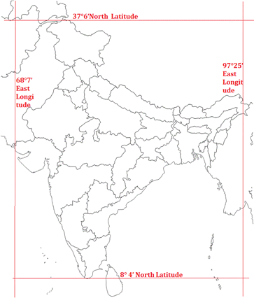
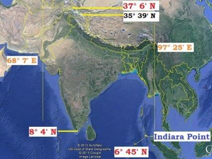
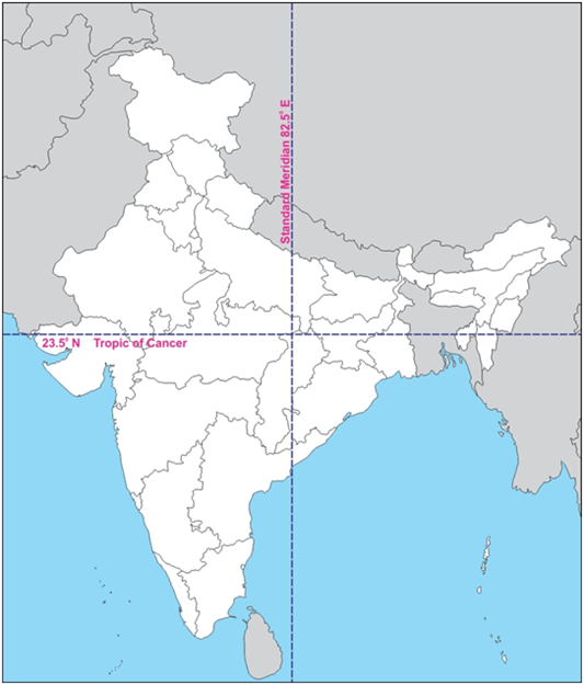
Answer: India is a vast country. Lying entirely in the Northern hemisphere the main land extends between latitudes 8°4′N and 37°6′N and longitudes 68°7′E and 97°25′E. The Tropic of Cancer (23° 30′N) divides the country into almost two equal parts.
3. What is the extent of coastline of mainland of India?
Answer: The total length of the coast line of the mainland including Andaman and Nicobar and Lakshadweep is 7,516.6 km.
4. What is the area of India?
Answer: The land mass of India has an area of 3.28 million square km. India’s total area accounts for about 2.4 per cent of the total geographical area of the world. India is the seventh largest country of the world. India has a land boundary of about 15,200 km.
5. Which mountain bounds India in northwest?
Answer: India is bounded by the young fold mountains in the northwest, north and north east. South of about 22° north latitude, it begins to taper, and extends towards the Indian Ocean, dividing it into two seas, the Arabian Sea on the west and the Bay of Bengal on its east.
6. What is the latitudinal and longitudinal extent of the mainland?
Answer: The latitudinal and longitudinal extent of the mainland is about 30°. Despite this fact the east-west extent appears to be smaller than the north-south extent.
7. Why is time along the Standard Meridian of India passing through Mirzapur taken as the standard time?
Answer: From Gujarat to Arunachal Pradesh there is a time lag of two hours. Hence, time along the Standard Meridian of India (82°30′E) passing through Mirzapur (in Uttar Pradesh) is taken as the standard time for the whole country.
8. How is India connected to the world through the sea routes?
Answer: The Trans Indian Ocean routes which connect the countries of Europe in the West and the countries of East Asia provide a strategic central location to India.
Note that the Deccan Peninsula protrudes into the Indian Ocean, thus helping India to establish close contact with West Asia, Africa and Europe from the western coast and with Southeast and East Asia from the eastern coast.
9. How has the opening of the Suez Canal helped in reducing India’s distance from Europe?
Answer: Since the opening of the Suez Canal in 1869, India’s distance from Europe has been reduced by 7,000 km.
10. How has land routes contributed in the exchange of ideas and commodities since ancient times?
Answer: The land routes have contributed in the exchange of ideas and commodities since ancient times. The ideas of the Upanishads and the Ramayana, the stories of Panchtantra, the Indian numerals and the decimal system thus could reach many parts of the world. The spices, muslin and other merchandise were taken from India to different countries. On the other hand, the influence of Greek sculpture, and the architectural styles of dome and minarets from West Asia can be seen in different parts of India.
11. What is the number of states in India?
Answer: India has 28 states and 8 Union Territories.
12. Which countries share land border with India?
Answer: India shares its land boundaries with Pakistan and Afghanistan in the northwest, China (Tibet), Nepal and Bhutan in the north and Myanmar and Bangladesh in the east.
13. Which two island countries are southern neighbours of India?
Answer: India’s southern neighbours across the sea consist of the two island countries, namely Sri Lanka and Maldives.
14. How is Sri Lanka separated from India?
Answer: Sri Lanka is separated from India by a narrow channel of sea formed by the Palk Strait and the Gulf of Mannar.
15. Jammu and Kashmir, Himachal Pradesh, Uttarakhand, Sikkim, Arunachal Pradesh share international boundaries with which country?
Answer: China.
16. Which country’s land boundary is surrounded by India’s land boundary in the north-west?
Answer: Pakistan’s land boundary is surrounded by India’s land boundary in the north-west.
17. Which neighbouring country is located in the West of India?
Answer: Pakistan.
18. Which Strait separates Sri Lanka from India?
Answer: Sri Lanka is separated from India by a narrow channel of sea formed by the Palk Strait and the Gulf of Mannar.
19. Which two island countries are India’s neighbours?
Answer: Sri Lanka and the Maldives are the two island countries.
20. What is the longitudinal extent of India? State its two implications. [Important]
Answer: The mainland of India extends between longitudes 68°7′E and 97°25′E. The east-west extent is 2933 km in length.
The longitudinal extension shows that India is located in the Eastern Hemisphere and places can be located with reference to longitudes.
On account of the 30° longitudinal extension (97°25′– 68°7′ = 29°18′, approximately 30°) there is a time difference of 2 hours (30°×4 min = 120 mins or 2 hours) in local time between the eastern and western limits of India. However, a standard time (5 hours 30 min ahead of G.M.T.) is adopted according to the local time of the central meridian of the country, 82°30′E.
21. Mention the latitudinal extent of India. How does it influence the duration of the day and night at different places?
Answer: (a) The latitudinal extent of India is 8°4’N and 37°6’N.
(b) The day and night are near to the same duration at the equator. As Kanyakumari is quite near the equator at 8°4’N the day-night difference is hardly one hour there, and therefore, the difference in duration of day and night is hardly felt at Kanyakumari.
On the other hand, as we move away from the equator to the poles the variations in duration of day and night become greater. Kashmir is over 30° away from the equator and so the difference in duration of day and night is more there and we feel that difference.
22. What is the latitudinal extent of India? How does it affect India?
Answer: The latitudinal extension of the mainland of India is between 8°4′ N and 37°6′ N. The north south extension is 3214 km in length.
The latitudinal extension shows that India is located entirely in the Northern Hemisphere. The wide latitudinal extent of nearly 30 degrees results in wide variation in climate. The southern parts gets more heat from the sun than the northern parts. Differences in the duration of day and night is much less in the south of India at lower latitudes, e.g. as in Kanyakumari. But the difference increases further north, e.g. as in Jammu and Kashmir, as it is further away from the equator.
23. Describe briefly the geographic location of India in Asia. What is the significance of India’s geographic location?
Answer: The Indian landmass has a central location between the East and the West Asia. India is a southward extension of the Asian Continent.
The trans-Indian Ocean routes which connect the countries of Europe in the west and the countries of East Asia provide a strategic central location to India. The Deccan Peninsula protrudes into the Indian Ocean, thus helping India to establish close contact with oil rich countries of West Asia as well as Africa and Europe from the western coast and the Southeast and East Asia from the eastern coast via sea and ocean routes and air routes.
24. Why is the difference in the duration of day and night very little in Kanyakumari while it is not so in the northern part of the country? Give specific reasons for your answer.
Answer: Kanyakumari in Tamil Nadu is located at the southern-most tip of India’s mainland. The latitude 8°4′ N passes close to it.
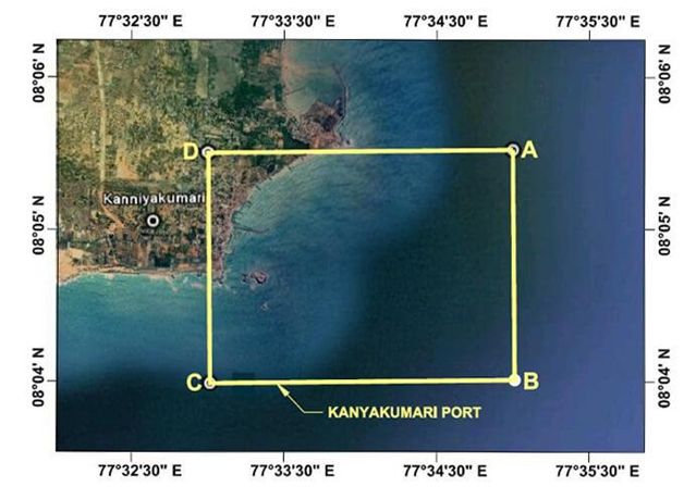
The place is thus near the equator and lies close to the equatorial region. As the sun shines directly over the equator all throughout the year, the duration of day and night is almost equal here. Hence, in Kanyakumari the difference in the duration of day and night is very little, maximum around 45 minutes only. But in the northern part of the country located to the north of the Tropic of Cancer away from the equator, the difference between the length of day and night becomes increasingly greater.
25. What is the southernmost point of the Indian Union called? Describe its location in India and its current situation.
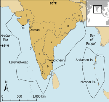
Answer: The southern-most point of the Indian Union is known as the Indira Point. It is located on the Nicobar Islands, the southern section of the Andaman and Nicobar group of islands. The islands are located in the Bay of Bengal lying to the southeast of India’s mainland.
The Indira Point got submerged under the seawater in December 2004 during the destructive Tsunami that hit the Andaman and Nicobar Islands.
26. How has the long coastline been beneficial to India?
Answer: The Arabian Sea and the Bay of Bengal, extensions of the Indian Ocean, lie to the west and east of Indian Peninsula, and the Indian Ocean lies to its south.
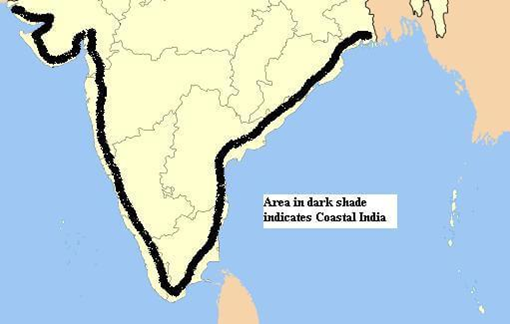
The total length of the coastline of the mainland of India including Andaman & Nicobar and Lakshadweep is 7516.6 km. The long coastline of India has helped in maritime trade since ages. The central location of India at the head of Indian Ocean has provided it a strategic location along the trans-Indian Ocean routes.
India is able to establish close contact with West Asia, Africa and Europe from western coast and with Southeast and East Asia from the eastern coast. The long coastline has also played a major role in influencing the climate of India. It provides opportunities for fishing and extraction of petroleum. It serves as a natural boundary protecting India.
27. What is the Standard Meridian of India? From where does it pass?
Answer: The Standard Meridian of India (82°30′ E) passing through Mirzapur in Uttar Pradesh is taken as the Standard time for the whole country.
28. How have mountain passes been helpful to India since historic times?
Answer: The various mountain passes across the Himalayan range and other mountains in the north have provided passages to travellers since ancient time. The land routes via mountain passes have contributed in the exchange of ideas and commodities since historic times.
The ideas of Upanishads and the Ramayana, the stories of Panchtantra, the Indian numerals and the decimal system could thus reach many parts of the world. The spices, muslin and other merchandise were taken from India to different countries. On the other hand, the architectural styles of dome and minarets from West Asia and influence of Greek sculpture, which can be seen in different parts of India, came from other countries to India.
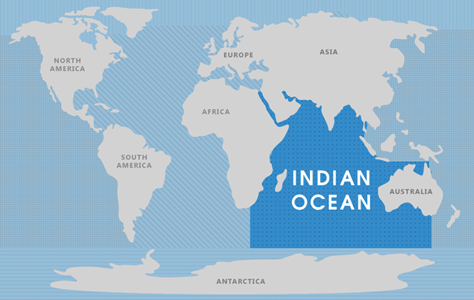
29. Which ocean is named after India? Give two reasons as to why it was named after India.
Answer: The Indian Ocean is named after India. India is the only country which has the credit of an ocean named after it.
The Arabian Sea and the Bay of Bengal, extensions of the Indian Ocean, lie to the west and east of Indian Peninsula, and the Indian Ocean lies to its south. No other country has a long coastline on the Indian Ocean as India. The central location of India at the head of the Indian Ocean has provided India a strategic location of great significance along the trans-Indian Ocean route. It is India’s eminent position in the Indian Ocean which justifies the naming of the ocean after India.
30. What was the contribution of land routes to India in ancient times? Explain any three.
Answer: India’s contacts with the outside world have continued through the ages, through the land routes and sea routes.
(i) These routes have contributed in the exchange of ideas and commodities since ancient times. The ideas of Upanishads and the Ramayana, the stories of Panchtantra, the Indian numerals and the decimal system could reach many parts of the world.
(ii) The spices, muslin and other merchandise were taken away from India to different countries through this land routes.
(iii) The influence of Greek sculpture and the architectural styles of domes and minarets from West Asia can be seen in different parts of our country.
31. Which meridian has been selected as the Standard Meridian of India?
Answer: (i) 82°32′ E has been selected as the Standard Meridian of India.
(ii) From Gujarat to Arunachal Pradesh, there is a time lag of two hours. To bring the whole country under one time set, 82°32′ E latitude which passes at the centre of the country is taken as a standard time for the whole country in order to maintain uniformity of time.
32. Why India is called a subcontinent? Write any three points.
Answer: India is called a subcontinent because of the following reasons:
(i) It is a distinct geographic unit separated from the Asian continent by the majestic Himalayas and its extensions.
(ii) It has its own culture as distinct from the rest of Asia.
(iii) The climate of Indian subcontinent is characterised by monsoon type of climate.
33. What is latitude? What is the latitudinal extent of India?
Answer: (i) The position of a place, measured in degrees North or South of the equator. It is mostly calculated on the basis of angular distance of a place north-south of the equator.
(ii) The main land of India extends between latitudes 8°4′ N and 37°6′ N and longitudes 68°7′ E and 97°25′ E.
34. Name the southernmost point of Indian Union. It is visible today?
Answer: The southernmost point of the Indian union is ‘Indira point’.
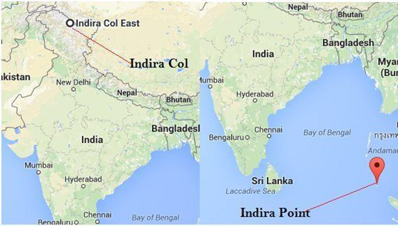
It submerged under the sea water in 2004 during the Tsunami. The entire landmass was erased from the map of India.
35. Do you think naming the Indian Ocean after a country is justified. Why?
Answer: Yes, because no other country has a long coastline on the Indian Ocean as India has. It is because of India’s eminent position in the Indian Ocean which justifies the naming of an ocean after it.
36. How does India occupy an important strategic position in South Asia? Illustrate your answer by explaining three suitable points.
Answer: India occupies an important strategic position in South Asia on the following points:
(i) The Indian landmass has a central location between the East and the West Asia.
(ii) The trans-Indian ocean routes which connect the countries of Europe in the west and the countries of East Asia provide a strategic central location to India.
(iii) The Deccan peninsula protrudes into the Indian Ocean has helped India to establish close contact with West Asia, Africa and Europe from the western coast and with Southeast and East Asia from the eastern coast.
37. What is latitudinal extent of India? How is the latitudinal spread in India advantageous to her? State two points.
Answer: The latitudinal extent of India lies between 8°4′ N and 37°6′ N. This means that the longitudinal expanse is about 30° from west to east. The advantages of longitudinal spread:
(i) influences the duration of the day and night as one moves from South to North
(ii) It also helps to take advantages of the Indian Ocean, the Arabian Sea on the west and the Bay of Bengal on its east for sea movements.
38. Give a reason for the following statement :
(a) 82° 30 E Latitude has been selected as the Standard Meridian of India.
(b) The distance between India and Europe has been reduced by 7000 km. with the opening of Suez Canal.
(c) Days and night are almost of equal duration at Kanyakumari.
Answer: (a) There is a time lag of at least 2 hours if one moves from west to east – from Gujarat to Arunachal Pradesh. The local time at Arunachal Pradesh would be at least 2 hours ahead of Gujarat. To avoid such differences in local time, Indian Standard Time (IST) has been fixed on 82°30′ E to give the whole country a uniform time.
(b) Before the opening up of Suez Canal in 1869, ships from Europe had to make detour journey via (Cape of Good Hope) African coast after traversing a distance of about 15000 km.
(c) Kanyakumari in Tamil Nadu is located at the southern-most tip of India’s mainland. The latitude 8°4′ N passes close to it. The place is thus near the equator and lies close to the equatorial region. As the sun shines directly over the equator throughout the year, the durations of day and night are almost equal here. Hence, in Kanyakumari the difference in the duration of day and night is very little, maximum around 45 minutes only.
39. Why is there a difference of 2 hours in local time between the eastern-most part of Arunachal Pradesh and western-most part of Gujarat? Explain.
Answer: The local time in Arunachal Pradesh is two hours ahead of Gujarat because of longitudinal differences. Time is calcullated on the basis of 4 minutes for every 1° of longitude towards East and West of Greenwich Meridian Time (GMT). The difference between Arunachal and Gujarat is 30° East longitude. Therfore, the differences of time between these two places 30 × 4 = 120 minutes or two hours.
40. Explain why Ahmedabad and Kolkata are able to see the noon sun exactly overhead in a year but not Delhi.
Answer: Kolkata and Ahmedabad is located very close to the Tropic of Cancer and as such both the places see the noon exactly overhead in a year. Delhi, on the other hand is located far north of the Tropic of Cancer and does not enjoy it.
41. Why do we need a Standard Meridia for India? Explain.
Answer: Due to vastness of the country there is a difference of time between places as one moves from east to west and vice versa. In order to set right this problem Stardard Meridia is needed.