Class 9 Geography Chapter 2 Important Questions Physical Features of India
Class 9 Social Science Geography Chapter 2 Physical Features of India important questions and answers cover the major concepts of the chapter. Solving answers of these important questions help students to revise the Chapter most competently. We prepared these questions with PDF as per the latest NCERT book and CBSE syllabus. Practising these questions before the exam will ensure excellent marks in the exam.
Physical Features of India Class 9 Important Questions and Answers
1. Describe the Theory of Plate Tectonics.
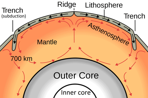
Answer: A plausible theory presented by earth scientists to explain the formation of continents and ocean basins and the various land forms is the ‘Theory of Plate Tectonics’. According to the theory, the crust of the earth has been formed out of seven major and some minor tectonic plates.
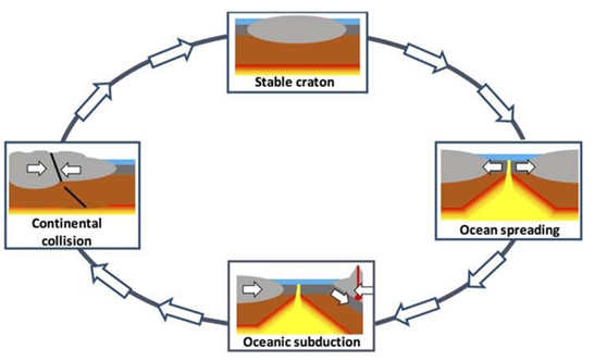
According to the earth scientists, millions of years ago, the world comprised of a supercontinent ‘Pangaea’ surrounded by the primeval ocean ‘Panthalasa’. The present continents and intervening oceans were formed due to splitting of the crust into plates due to convection currents and drifting of these plates.
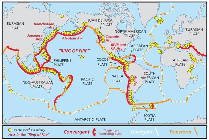
2. Where would one find most of the volcanoes and earthquake zones in the world and why?
Answer: Most volcanoes and earthquake zones in the world are located at plate margins. According to the ‘Theory of Plate Tectonics’ presented by earth scientists, the crust of the earth has been formed out of seven major and some minor plates.
The movement of these plates due to convection currents results in the building up of stresses within the plates and continental rocks above. This leads to folding, faulting and volcanic activity along the zones of maximum stress, i.e., mostly along the margins of the plates. Earthquake and volcanic activity are maximum here.
The circum-Pacific region – popularly termed as the Pacific Ring of Fire on account of its volcanoes and frequent earthquakes – lies along the margin of tectonic plates.
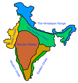
Ques 3. Name the different major physiographic divisions of India. Write a note on any one of the physiographic divisions of India.
Answer: The major physiographic divisions of India are as follows :
(i) The Himalayan Mountains
(ii) The Northern Plains
(iii) The Peninsular Plateau
(iv) The Indian Desert
(v) The Coastal Plains
(vi) The Islands
The Coastal Plains: The Peninsular Plateau of India is flanked by a stretch of narrow coastal plains to its west and east. The Western Coastal Plain is a narrow strip of plain stretching along the Arabian Sea lying to its west and flanked by the Western Ghats to its east. The northern part of the West Coast is called the Konkan (Mumbai to Goa), the central stretch is called the Kannad while the southern part is called the Malabar Coast.The Eastern Coastal Plain is comparatively wide and level stretch running along the Bay of Bengal lying to its east with the Eastern Ghats rising to its west. It is known as Northern Circar in the north, while its southern part is referred to as the Coromandal Coast.
4. How was the Great Northern Plains of India formed? Give a brief description.
Answer: The formation of the Himalayas due to upliftment of sediments out of the Tethys Sea and subsidence of the northern flank of the Peninsular Plateau resulted in the formation of a large basin.
Over millions of years this depression gradually got filled up with alluvium deposited by the three major river systems – the Indus, the Ganga and the Brahmaputra flowing from the Himalayas in the north. Sediments were also deposited by the tributaries of these rivers rising from the mountains in the north as well as the Peninsular Plateau to its south. As a result, the fertile Indo-Gangetic or Northern Plains, and the Brahmaputra Plain in the northeast, were formed.
As the Himalayas gained in height, the rivers, glaciers and other agents of denudation became increasingly active in erosion. As a result, large amount of silt got deposited in the shrinking Tethys.
5. Where are the Western and the Eastern Ghats situated? Write a small note on each.
Answer: The Western and the Eastern Ghats are situated in the Peninsular Plateau region. The Western Ghats mark the western edge of the Deccan Plateau and lie parallel to the Western Coast.
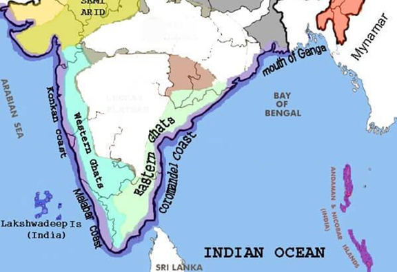
The Eastern Ghats mark the eastern edge of the Deccan Plateau. They stretch from the Mahanadi Valley to the Nilgiri Hills in the south. The eastern coastal plain runs to its east. The Western Ghats are continuous and regular and can be crossed only through passes like the Thal, Bhor and the Pal Ghats.
They are comparatively high in elevation (average 900 to 1600 metres). No major river cuts across the Western Ghats.The Eastern Ghats are discontinuous and irregular. They are of relatively lower elevation (average 600 m). They are dissected by rivers draining into the Bay of Bengal.
6. What is the Great Himalaya? Write two characteristics of it.
Answer: The northernmost range of the Himalayas is known as the Great or Inner Himalayas or the Himadri.
(i) It is the most continuous range consisting of the loftiest peaks with an average height of 6000 metres. It contains all the prominent Himalayan peaks.
(ii) Its folds are asymmetrical in nature and its core is composed of granite rock. It is perennially snow bound and contains many glaciers.
7. Define tectonic or lithospheric plates.
Answer: Earth scientists have put forward the view that the Earth’s crust or the lithosphere is not a continuous block.
It consists of several large and small, rigid, irregularly shaped plates (slabs) which include continents and the ocean floor. These slabs are moving or drifting in relation to each other by about 2.5 cm to 5 cm each year.
These crustal slabs are called tectonic or lithospheric plates. According to the ‘Theory of Plate Tectonics’ put forward by the Earth scientists, the earth’s crust has been formed out of seven major and some minor tectonic plates or lithospheric plates.
8. Which plateau lies between the Aravali and the Vindhya range? Write a brief note on this plateau.
Answer: The Malwa Plateau lies between the Aravali hills and the Vindhya range. The Aravali hills lie to the west of the plateau and the Vindhya range lies to its south. The part of the peninsular plateau lying to the north of the Narmada river, covering a major area of the Malwa plateau, is known as the Central Highlands.
The Malwa plateau lies in Madhya Pradesh. It is composed of extensive lava flows. There are rolling plains separated by flat-topped hills. The plateau is largely broken in form of ravines near the Chambal Valley in its east.
9. What do you understand by ‘duns’? Where are they situated in our country? Give any two examples of duns.
Answer: The longitudinal valleys lying between Lesser Himalaya and the Shivaliks are known as duns. Dehradun and Kotli Dun are two examples of duns.
10. What are corals? Name and describe the island group which is of coral origin.
Answer: Corals are short-lived microscopic organisms, which lives in colonies. They flourish in shallow, mud-free and warm waters.
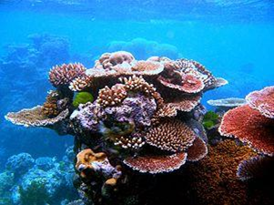
They secrete calcium carbonate. The coral secretion and their skeletons form coral deposits. Lakshadweep islands group lying close to the Malaber Coast of Kerala is composed of small coral islands.
11. Describe ‘Bhabar’ and ‘Terai’.
Answer: Bhabar is pebble studded formation situated at the base of mountains and plains in the Himalayan region. Terai is a sloping land at the foothills of the Nepal Himalayas. The Terai receives heavy rainfall and is densely forested.
12. Name any three divisions of Himalayas on the basis of regions from West to East and also write one main feature of each.
Answer: The Himalayas have been divided on the basis of regions from west to east. These divisions have been demarcated by river valleys.
(i) The part of Himalayas lying between Indus and Sutlej has been traditionally known as Punjab Himalayas. It is also regionally known as Kashmir Himachal Himalaya from west to east respectively.
(ii) The part of Himalayas lying between Sutlej and Kali rivers is known as Kumaon Himalayas.
(iii) The Kali and Tista rivers demarcate the Nepal Himalayas and the part lying between Tista and Dihang rivers is known as Assam Himalayas.
13. Why are the Himalayas called young fold mountains?
Answer: The Himalayan mountain is geologically young and structurally fold mountains stretch over the northern parts of India. It was uplifted from the ‘Tethys Sea’ during the Tertiary period. The whole mountain represents a very youthful topography with high peaks, deep valleys and fast flowing rivers. That is why it is called an young-fold mountain.
14. The relief of India displays a great physical variation. Explain.
Answer: India is a vast country with varied land forms. It has high mountains, plains, plateaus, islands, deserts etc. This varied large landmass formed during different geological periods which has influenced her relief.
Besides geological formations, a number of processes such as weathering, erosion and deposition have created and modified the relief to its present form. It is, therefore, India displays a great physical variation.
15: Describe the important features of the Peninsular Plateau.
Answer: The Peninsular Plateau of India lies to the south of the Northern Plains and extends up to the tip of the Indian peninsula. The Peninsular Plateau is a tableland with gently rising rounded hills and broad, shallow valleys.
It is roughly triangular in shape. It is the oldest and the most stable landmass of India. The plateau is formed of old crystalline igneous and metamorphic rocks.
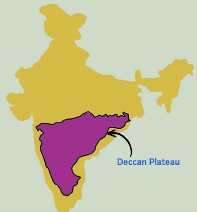
The Peninsular Plateau consists of two broad divisions – the Central Highlands and the Deccan Plateau. The part of the Peninsular plateau lying to the north of the Narmada river is known as Central Highlands.
It comprises of Malwa Plateau, Bundelkhand and Baghelkhand plateaus, the Vindhya Range and extends as Chhota Nagpur Plateau. The Aravalis are highly denuded old hills that lie on the western and northwestern margins of the Peninsular Plateau. The part of the Peninsular Plateau lying to the south of river Narmada is known as Deccan Plateau.
It is a triangular landmass with broad base in the north and tapers southward. It is formed due to lava flows, so a greater part of it is composed of basaltic rocks of volcanic origin.
It is flanked by the Satpura range in the north. The Mahadev, the Kaimur hills and Maikal range from its eastern extensions. The Deccan Plateau is flanked by the Western Ghats in the west and Eastern Ghats in the east.
The Western Ghats have comparatively higher elevation of average 900 to 1600 metres. The Eastern Ghats have an average elevation of 600 metres. So the plateau is higher in the west and slopes gently eastwards. The black soil area of the Deccan Plateau is known as Deccan Trap.
16: Write a note on the different parts of the Great Himalayan range.
Answer: The Himalayas are the one of the loftiest and most rugged mountain systems of the world. The mountain ranges of the Himalayas run in a west-east direction from the Indus to the Brahmaputra, stretching along the entire northern boundary of India. Geologically they are young and structurally fold mountain system.
The Himalayas consists of three sections comprising parallel ranges running from west to east. The nothern-most section is known as the Greater or Inner Himalayas. On account of its permanent snow cover and glaciers the section is also termed as Himadri.
It is the most continuous section. The average height of these ranges is 6000 metres. All the prominent and loftiest peaks of the Himalayas are located here. Some of prominent peaks are the Everest (8848 m) in Nepal, Kanchenjunga (8598 m in Sikkim), Nanga Parbat (in Kashmir), Nanda Devi (Uttarakhand) and Namcha Barwa (in Tibet, near Arunachal Pradesh) and Dhaulagiri and Annapurna in Nepal.
To the south of Himadri lie the rugged ranges of the Lesser Himalayas or the Himachal. Their average width is 50 km. The average height ranges between 3700 and 4500 metres. The Pir Panjal range, the Dhaula Dhar and Mahabharat ranges are important ranges.
The famous valley of Kashmir, the Kangra and the Kullu Valleys in Himachal are located in this range. The outermost range of the Himalayas is called the Outer Himalayas or the Shivaliks. They extend over a width of 10-50 km. They are discontinuous ranges. Their average height is between 900 and 1100 metres.
They are composed of unconsolidated sediments, gravel and alluvium brought down by the rivers that rise in the northern ranges. Hence, they are the youngest section of the Himalayas.Longitudinal valleys known as duns lie between the Lesser Himalayas and Shivaliks, e.g., Dehra Dun, Kotli Dun, Patli Dun.
17: Describe the formation of India from Gondwanaland.
Answer: According to the ‘Theory of Plate Tectonics’ presented by earth scientists, the earth’s crust is composed of tectonic plates. The movement of these plates have influenced the evolution of present landforms of India.
The southern part of the ancient super-continent Pangaea is known as Gondwanaland. It included India, Australia, South Africa and South America as one single landmass. Geologically, the Peninsular Plateau, which is one of the oldest landmasses of the earth’s surface, was part of the Gondwanaland.
Tectonic forces split the crust into a number of plates. A part of the Gondwanaland, the Indo- Australian plate, drifted northwards. This resulted in the collision of this plate with the much larger Eurasian plate.
The intervening portion between Angaraland in the north and Gondwanaland in the south was occupied by Tethys Sea. Due to this collision, the sediments that had accumulated in the Tethys geosyncline was uplifted and folded. This resulted in the formation of the lofty Himalayas.
The Himalayan upliftment out of the sediments of the Tethtys Sea and subsidence of the northern flank of the Peninsular Plateau resulted in the formation of a large basin.
Over millions of years the depression gradually got filled with deposition of sediments by the rivers flowing from the mountains in the north and the Peninsular Plateau in the south.
The interplay of three major river systems – the Indus, the Ganga, the Brahmaputra and their tributaries formed a fertile, flat land of extensive alluvial deposits known as the Northern Plains.
18: Which part of the Himalayas is known as Purvanchal? Write a short note on the Purvanchal Himalayas.
Answer: The eastern hills and mountains of the Himalayas running along the eastern boundary of India is known as Purvanchal.
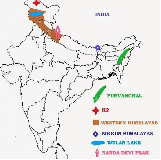
They are located in the northeastern states of India. The river Brahmaputra marks the easternmost boundary of the Himalayas. Beyond the Dibang gorge, the Himalayas bend sharply to the south and spread along India’s eastern border.
They are known as Purvanchal. They run mostly as parallel ranges with valleys in between. They are mostly composed of strong sandstone, a sedimentary rock. The Purvanchal are less spectacular than the Himalayas and are of medium height. The hills and ranges are covered with dense forests.
Some important hills of the Purvanchal are :
(i) the Patkai Bum and Naga hills
(ii) the Mizo hills and Manipur hills
(iii) the Garo, Khasi and Jaintia hills along Meghalaya-Bangladesh border.
(iv) the Dafla hills in the north.
19: Distinguish between the Northern Plains and the Peninsular Plateau. (Important)
Answer:
| The Northern Plains | The Peninsular Plateau |
| 1. Geologically, the Northern Plains were formed in recent geological period | 1. Geologically, the Peninsular Plateau is part of die Gondwanaland. die southern part of ancient super-continent Pangaea |
| 2. Northern Plains are the most recent landform | 2. The Peninsular plateau is part of oldest landmass. |
| 3. They are being formed and reshaped by the river systems. | 3. It is one of the most stable land blocks |
| 4. It is a fertile, level land | 4. It a plateau or tableland with rounded hills and wide shallow valleys. |
| 5. The Northern Plains are formed of alluvial deposits brought down by the rivers. | 5. The Peninsular Plateau is composed of old crystalline igneous and metamorphic rocks. |
| 6. The Northern Plains are divided into three sections: (i) The Punjab Plains formed by Indus and its tributaries, (ii) The Ganga Plains in North India (iii) The Brahmaputra Plains Assam | 6. The Peninsular Plateau is divided mainly into two broad divisions: (i) the Central Highlands and (ii) the Deccan Plateau |
| 7. The Northern Plains are covered with rich, fertile alluvial soil ideal for high agricultural production | 7. A distinct feature of the Peninsular Plateau is the black soil area known as Deccan Trap. This soil is ideal for growth of cotton. |
| 8. It is the most densely populated region of India on account of fertile soil, adequate water and favourable climate | 8. It has moderate density of population. |